IMAGES TAKEN NEAR TO
High Road, FELIXSTOWE, IP11 0SS
Introduction
This page details the photographs taken nearby to High Road, IP11 0SS by members of the Geograph project.
The Geograph project started in 2005 with the aim of publishing, organising and preserving representative images for every square kilometre of Great Britain, Ireland and the Isle of Man.

There are currently over 7.5m images from over14,400 individuals and you can help contribute to the project by visiting https://www.geograph.org.uk
Image Map
Images are licensed for reuse under creativecommons.org/licenses/by-sa/2.0
Notes
- Clicking on the map will re-center to the selected point.
- The higher the marker number, the further away the image location is from the centre of the postcode.
Image Listing (47 Images Found)
Images are licensed for reuse under creativecommons.org/licenses/by-sa/2.0
Image
Details
Distance
1
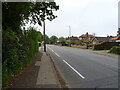
High Road, Trimley St Mary
National Cycle Route 51 towards Felixstowe.
Image: © JThomas
Taken: 13 May 2023
0.02 miles
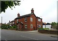
2
Three wheeler on High Road, Trimley St. Martin
Image: © Adrian S Pye
Taken: 17 Sep 2014
0.03 miles
3
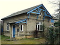
Trimley Free Church
This sweet little building is tucked away just off the High Road.
Image: © Oxymoron
Taken: 18 Feb 2009
0.04 miles
5
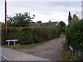
Gaymers Lane, Trimley St Mary & Keeper's Lane Bridleway
To Keepers Lodge off High Road, Trimley St Mary
Image: © Geographer
Taken: 13 Oct 2011
0.08 miles
6
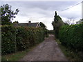
Gaymers Lane, Trimley St Mary & Keeper's Lane Bridleway
To Keepers Lodge off High Road, Trimley St Mary
Image: © Geographer
Taken: 13 Oct 2011
0.08 miles
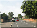
7
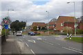
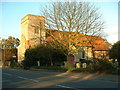
High Road, Trimley St Mary
Faulkeners Way leads off to the right at this mini-roundabout. Both Trimley St Mary and Trimley St Martin are by-passed by the modern A14 so that port traffic does not have to come this way.
Image: © Stephen McKay
Taken: 26 Mar 2018
0.11 miles
8
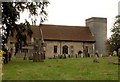
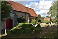
St. Mary's; the parish church of Trimley St. Mary
This church shares its churchyard with the parish church of Trimley St. Martin and has not been in use as a church since the 1980s. It is now used as a multi-purpose community building. Although much of what is seen today is the result of heavy Victorian restoration, the church dates back to the 14th century.
Image: © Robert Edwards
Taken: 19 Sep 2007
0.15 miles
9
St. Mary's Church and churchyard, Trimley
Looking across the churchyard towards the Victorian rectory. The church is now used as an arts centre.
Image: © Simon Mortimer
Taken: 22 Aug 2020
0.16 miles
10
St. Mary's
St. Mary's, Trimley St. Martin, Ipswich Suffolk. http://www.suffolkchurches.co.uk/trimleymartin.html
http://www.geograph.org.uk/photo/283413
Image: © Keith Evans
Taken: 23 Nov 2006
0.16 miles