IMAGES TAKEN NEAR TO
Levington Road, IPSWICH, IP10 0EJ
Introduction
This page details the photographs taken nearby to Levington Road, IP10 0EJ by members of the Geograph project.
The Geograph project started in 2005 with the aim of publishing, organising and preserving representative images for every square kilometre of Great Britain, Ireland and the Isle of Man.

There are currently over 7.5m images from over14,400 individuals and you can help contribute to the project by visiting https://www.geograph.org.uk
Image Map
Images are licensed for reuse under creativecommons.org/licenses/by-sa/2.0
Notes
- Clicking on the map will re-center to the selected point.
- The higher the marker number, the further away the image location is from the centre of the postcode.
Image Listing (62 Images Found)
Images are licensed for reuse under creativecommons.org/licenses/by-sa/2.0
Image
Details
Distance
1
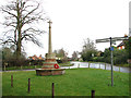
War Memorial at Nacton
Off Levington Road
Image: © Geographer
Taken: 13 Nov 2008
0.06 miles
6
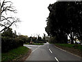
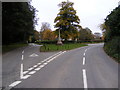
Ipswich Road, Nacton
At the junction with The Street
Image: © Geographer
Taken: 17 Mar 2014
0.16 miles
8
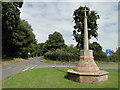
Nacton World War One Memorial
The Memorial stands at a road junction at the top of the village. It bears 18 names. The WW2 Memorial is in the church and can be seen here > http://www.geograph.org.uk/photo/4622574
Image: © Adrian S Pye
Taken: 19 Aug 2015
0.16 miles
9
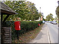
The Street, Nacton & Anchor House The Street Postbox
Postbox No.IP10 1216
Image: © Geographer
Taken: 10 Oct 2011
0.17 miles
10
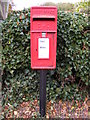
Anchor House The Street Postbox
Postbox No.IP10 1216
Image: © Geographer
Taken: 10 Oct 2011
0.17 miles