IMAGES TAKEN NEAR TO
Bucklesham Road, IPSWICH, IP10 0AA
Introduction
This page details the photographs taken nearby to Bucklesham Road, IP10 0AA by members of the Geograph project.
The Geograph project started in 2005 with the aim of publishing, organising and preserving representative images for every square kilometre of Great Britain, Ireland and the Isle of Man.

There are currently over 7.5m images from over14,400 individuals and you can help contribute to the project by visiting https://www.geograph.org.uk
Image Map
Images are licensed for reuse under creativecommons.org/licenses/by-sa/2.0
Notes
- Clicking on the map will re-center to the selected point.
- The higher the marker number, the further away the image location is from the centre of the postcode.
Image Listing (44 Images Found)
Images are licensed for reuse under creativecommons.org/licenses/by-sa/2.0
Image
Details
Distance
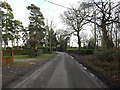
4
Bucklesham Road, Foxhall
Looking towards Warren Heath
Image: © Geographer
Taken: 2 Mar 2009
0.10 miles
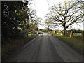
5
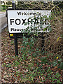
Foxhall Village Name sign
On Bucklesham Road
Image: © Geographer
Taken: 9 Jan 2014
0.10 miles
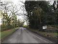
6
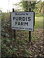
Purdis Farm Village Name sign
On Bucklesham Road
Image: © Geographer
Taken: 9 Jan 2014
0.10 miles
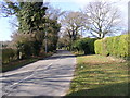
7
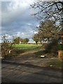
Footpath to Purdis Hall & Sandlings Walk
Off Bucklesham Road
Image: © Geographer
Taken: 9 Jan 2014
0.10 miles
8
Footpath to the A1156 Felixstowe Road
Off Buclesham Road near the Suffolk Agricultural Association Showground
Image: © Geographer
Taken: 9 Jan 2014
0.10 miles
9
Footpath to the A1156 Felixstowe Road
Off Buclesham Road near the Suffolk Agricultural Association Showground
Image: © Geographer
Taken: 9 Jan 2014
0.11 miles
10
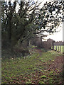
Footpath to Purdis Hall & Sandlings Walk
Off Bucklesham Road
Image: © Geographer
Taken: 9 Jan 2014
0.11 miles