IMAGES TAKEN NEAR TO
Birch Close, BUCKHURST HILL, IG9 6HR
Introduction
This page details the photographs taken nearby to Birch Close, IG9 6HR by members of the Geograph project.
The Geograph project started in 2005 with the aim of publishing, organising and preserving representative images for every square kilometre of Great Britain, Ireland and the Isle of Man.

There are currently over 7.5m images from over14,400 individuals and you can help contribute to the project by visiting https://www.geograph.org.uk
Image Map
Images are licensed for reuse under creativecommons.org/licenses/by-sa/2.0
Notes
- Clicking on the map will re-center to the selected point.
- The higher the marker number, the further away the image location is from the centre of the postcode.
Image Listing (26 Images Found)
Images are licensed for reuse under creativecommons.org/licenses/by-sa/2.0
Image
Details
Distance
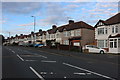
6
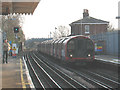
Looking south from Buckhurst Hill station
Image: © Stephen Craven
Taken: 20 Mar 2009
0.15 miles
7
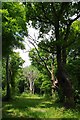
Ancient Pollards in Lord's Bushes
Lord's Bushes is part of Epping Forest https://www.cityoflondon.gov.uk/things-to-do/green-spaces/epping-forest/visitor-information/wheretogoineppingforest/Pages/knighton-wood.aspx
Image: © Glyn Baker
Taken: 25 May 2017
0.17 miles
8
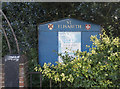
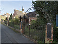
St Elisabeth, Buckhurst Hill - Noticeboard
Image: © John Salmon
Taken: 13 Nov 2017
0.17 miles