IMAGES TAKEN NEAR TO
Farm Close, BUCKHURST HILL, IG9 5AJ
Introduction
This page details the photographs taken nearby to Farm Close, IG9 5AJ by members of the Geograph project.
The Geograph project started in 2005 with the aim of publishing, organising and preserving representative images for every square kilometre of Great Britain, Ireland and the Isle of Man.

There are currently over 7.5m images from over14,400 individuals and you can help contribute to the project by visiting https://www.geograph.org.uk
Image Map
Images are licensed for reuse under creativecommons.org/licenses/by-sa/2.0
Notes
- Clicking on the map will re-center to the selected point.
- The higher the marker number, the further away the image location is from the centre of the postcode.
Image Listing (20 Images Found)
Images are licensed for reuse under creativecommons.org/licenses/by-sa/2.0
Image
Details
Distance
1
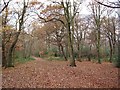
Knighton Wood in winter
Knighton Wood with the adjacent Lords Bushes forms a small isolated patch of Epping Forest, surrounded by housing. It was enclosed in the nineteenth century from the forest to form the ornamental gardens of Knighton House, the home of the Buxton family, and returned to the Forest in 1930.
Image: © John Davies
Taken: 13 Dec 2005
0.07 miles
2
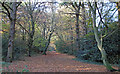
Monkhams Lane
This ancient trackway forms the boundary between Knighton Wood (to the south) and Lord's Bushes (to the north). In the past this was the old Anglo-Saxon boundary between the Manors of Chigwell and Woodford. Today it is the boundary between Essex and Greater London.
See also Image]
Image: © Roger Jones
Taken: 19 Nov 2011
0.12 miles
3

Footbridge over dry stream in Knighton Wood
Image: © Roger Jones
Taken: 19 Nov 2011
0.12 miles


10
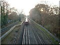
Roding Valley Junction
Here the Hainault loop line joins the main Epping branch of the Central Line. The view is to the south and train is travelling south towards Woodford and London. The branch line to the left leads to Roding Valley station and the viaduct shown in Image, then to Grange Hill, Hainault and Newbury Park, rejoining the main line at Leytonstone.
Image: © John Davies
Taken: 13 Dec 2005
0.20 miles