IMAGES TAKEN NEAR TO
Love Lane, WOODFORD GREEN, IG8 8BB
Introduction
This page details the photographs taken nearby to Love Lane, IG8 8BB by members of the Geograph project.
The Geograph project started in 2005 with the aim of publishing, organising and preserving representative images for every square kilometre of Great Britain, Ireland and the Isle of Man.

There are currently over 7.5m images from over14,400 individuals and you can help contribute to the project by visiting https://www.geograph.org.uk
Image Map (Loading...)


Getting Data...Please wait
Leaflet Map data © OpenStreetMap
Images are licensed for reuse under creativecommons.org/licenses/by-sa/2.0
Notes
- Clicking on the map will re-center to the selected point.
- The higher the marker number, the further away the image location is from the centre of the postcode.
Image Listing (44 Images Found)
Images are licensed for reuse under creativecommons.org/licenses/by-sa/2.0
Image
Details
Distance
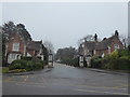
1
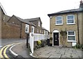
Love Lane at the junction of Turpin's Lane
Image: © David Howard
Taken: 4 Nov 2017
0.03 miles

4
Repton Park, Woodford Bridge
Repton Park is a housing development in a converted hospital. The hospital was built on the edge of London in the late 19th Century as an asylum for people with mental illnesses and disabilities. It closed in the 1990s.
Image: © Malc McDonald
Taken: 25 May 2013
0.12 miles
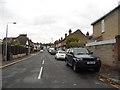
5
Hidden bungalow on Turpin's Lane, Woodford
For unknown reasons this was built side on to the road and invisible to the public.
Image: © David Howard
Taken: 4 Nov 2017
0.14 miles
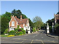
6
Entrance to Repton Park
Repton Park was named after Humphry Repton, the last great English landscape designer of the 18th century. He advised on landscaping the parkland of the Claybury estate which was developed into a fine gentleman's estate from 1786 by James Hatch. Hatch built a new mansion, expanded the estate and it was he who commissioned Humphry Repton. In 1887 the estate was sold and Claybury Asylum was built by 1893 on the brow of a hill, the first mental hospital built by the new London County Council. From 1893 to 1918 it was called Claybury Asylum, from 1918 to 1937 Claybury Mental Hospital, and from 1937 to its closure in 1995 Claybury Hospital
In 1997 the Health Authority sold the Hospital estate for an exclusive private housing development, renamed Repton Park, but 18 hectares of ancient woodland and 38 hectares of parkland became part of a new public park, Claybury Park. This also incorporated Redbridge Open Space to the south, itself part of the Claybury estate until the 1880s.
For more about Claybury Hospital see http://hidden-london.com/gazetteer/claybury/ and http://ezitis.myzen.co.uk/claybury.html and https://en.wikipedia.org/wiki/Claybury_Hospital
Image: © Marathon
Taken: 25 Jan 2017
0.14 miles
7
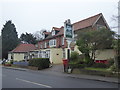
The Three Jolly Wheelers, Chigwell Road
The Three Jolly Wheelers was built in the early 19th century, and originally relied heavily on the tourist trade. A photograph of the inn taken in 1906 shows that the inn used to hire out horses and traps, which were most likely for day-trippers travelling to Epping Forest. It is just a few yards over the border from the London Borough of Redbridge into Essex.
Image: © Marathon
Taken: 25 Jan 2017
0.15 miles
8
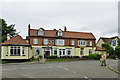
The Three Jolly Wheelers
On the A113 Chigwell Road, just on the Essex side of the boundary with Greater London.
Image: © Robin Webster
Taken: 2 Jun 2012
0.15 miles
9
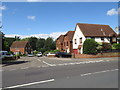
The Childers, Chigwell
The Childers is a small development of houses in Chigwell in Essex.
Image: © Malc McDonald
Taken: 17 Aug 2019
0.16 miles
10
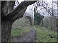
Woodland path off Chigwell Road
This secondary woodland is on a former landfill site and as a result visitors are advised on the notice at the entrance not to dig down anywhere!
Image: © Marathon
Taken: 25 Jan 2017
0.16 miles