IMAGES TAKEN NEAR TO
Bramble Close, CHIGWELL, IG7 6DR
Introduction
This page details the photographs taken nearby to Bramble Close, IG7 6DR by members of the Geograph project.
The Geograph project started in 2005 with the aim of publishing, organising and preserving representative images for every square kilometre of Great Britain, Ireland and the Isle of Man.

There are currently over 7.5m images from over14,400 individuals and you can help contribute to the project by visiting https://www.geograph.org.uk
Image Map
Images are licensed for reuse under creativecommons.org/licenses/by-sa/2.0
Notes
- Clicking on the map will re-center to the selected point.
- The higher the marker number, the further away the image location is from the centre of the postcode.
Image Listing (27 Images Found)
Images are licensed for reuse under creativecommons.org/licenses/by-sa/2.0
Image
Details
Distance
1

Thank you for visiting Chigwell Grange
Well I didn't really, I just walked past.
Image: © Robin Webster
Taken: 1 Apr 2013
0.04 miles
2
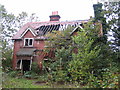
Chigwell: Former Grange Farm house
The Grange on the High Road was one of Chigwell's oldest houses, dating from the 15th century, but it was demolished after a fire in 1939. This building was the estate farm house that was built in the 1880s or 1890s. (It appears on the Ordnance Survey map of 1896 but not on the map of 1882.) It too has been fire damaged and is now sadly derelict and gutted.
Image: © Nigel Cox
Taken: 25 Oct 2006
0.08 miles
3

Chigwell: Grange Farm lane
This no through road off the High Road leads to the Vitalise charity's Jubilee Lodge http://www.vitalise.org.uk/Home.aspx
Image: © Nigel Cox
Taken: 25 Oct 2006
0.08 miles
4

Gate on Grange Farm Lane
The lane gives access to the Grange Farm Centre (some way behind the camera), a recreation and leisure centre.
Image: © Robin Webster
Taken: 1 Apr 2013
0.09 miles
5

Entrance to Chigwell Grange
A new gated greenfield development.
Image: © Robin Webster
Taken: 1 Apr 2013
0.09 miles
6

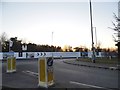
Chigwell Grange Gated Community
Thankfully, gated communities are rare in the UK and are usually associated with countries that suffer high levels of violent crime. There are some though, including this housing estate on the outskirts of Chigwell. It was built around 2013 and described by its developers as a 'private gated oasis of forty-three homes, set in and around stunning landscaped gardens, creating a spacious and beautiful environment'. Be that as it may, the high walls and metal gates present an unfriendly and unwelcoming face to the passer-by; perhaps that is the intention. See Image for a view of how this gateway looked in April 2013.
Image: © Stephen McKay
Taken: 22 Nov 2022
0.10 miles
7
New development by High Road, Chigwell
It's called Chigwell Village and as yet completely unstarted although begun back in the summer.
Image: © David Howard
Taken: 25 Feb 2018
0.11 miles
8
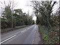
High Road, Chigwell
According to Pevsner, Charles Dickens called Chigwell "such an out of the way rural place". Pevsner goes on to say: "The visitor today is surprised to find it still a real village, the first as one leaves London in a north-east direction." This was written though in the 1950s but Chigwell still has the feel of a village as one heads up the hill away from the underground station towards St Mary's Church.
This view is beyond the old village on the way to Debden or Abridge.
Image: © Marathon
Taken: 8 Mar 2017
0.11 miles
9
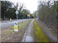
Alongside High Road, Chigwell
The keep left bollard looks slightly out of place and I am not sure what purpose it is serving here. This track with the moss in the middle just leads to an electricity substation.
Image: © Marathon
Taken: 8 Mar 2017
0.11 miles
10
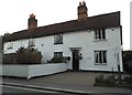
Dickens Cottage, Chigwell
Dickens wrote about the King's Head Chigwell in Barnaby Rudge and created a connection with the town since. http://www.british-history.ac.uk/vch/essex/vol4/pp18-22
Image: © David Howard
Taken: 25 Feb 2018
0.13 miles