IMAGES TAKEN NEAR TO
Roding Lane, CHIGWELL, IG7 6BE
Introduction
This page details the photographs taken nearby to Roding Lane, IG7 6BE by members of the Geograph project.
The Geograph project started in 2005 with the aim of publishing, organising and preserving representative images for every square kilometre of Great Britain, Ireland and the Isle of Man.

There are currently over 7.5m images from over14,400 individuals and you can help contribute to the project by visiting https://www.geograph.org.uk
Image Map
Images are licensed for reuse under creativecommons.org/licenses/by-sa/2.0
Notes
- Clicking on the map will re-center to the selected point.
- The higher the marker number, the further away the image location is from the centre of the postcode.
Image Listing (6 Images Found)
Images are licensed for reuse under creativecommons.org/licenses/by-sa/2.0
Image
Details
Distance
1
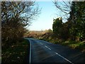
Roding Lane, Chigwell
Looking west along Roding Lane, Chigwell, a peaceful looking scene but in reality a constant roar from the M11 shatters the peace. The motorway and river Roding both run north-south just beyond the bend in the road and Buckhurst Hill can be seen across the valley.
Image: © John Davies
Taken: 19 Dec 2005
0.08 miles
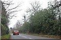
5
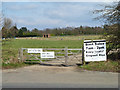
Boot sale site, Chigwell
Routinely on Saturdays, but a sign on the gate adds bank holiday Monday. This is odd, as this view was taken on Easter Monday, only forty minutes after finishing time, yet the site looks remarkably clear and locked up.
Image: © Robin Webster
Taken: 1 Apr 2013
0.24 miles
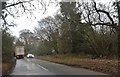
6
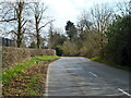
Roding Lane
Heading towards Chigwell High Road.
Image: © Robin Webster
Taken: 1 Apr 2013
0.25 miles