IMAGES TAKEN NEAR TO
Stradbroke Park, Tomswood Road, CHIGWELL, IG7 5QL
Introduction
This page details the photographs taken nearby to Stradbroke Park, Tomswood Road, IG7 5QL by members of the Geograph project.
The Geograph project started in 2005 with the aim of publishing, organising and preserving representative images for every square kilometre of Great Britain, Ireland and the Isle of Man.

There are currently over 7.5m images from over14,400 individuals and you can help contribute to the project by visiting https://www.geograph.org.uk
Image Map
Images are licensed for reuse under creativecommons.org/licenses/by-sa/2.0
Notes
- Clicking on the map will re-center to the selected point.
- The higher the marker number, the further away the image location is from the centre of the postcode.
Image Listing (5 Images Found)
Images are licensed for reuse under creativecommons.org/licenses/by-sa/2.0
Image
Details
Distance
1
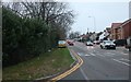
Tomswood Hill, Woodford
The Essex border runs in the middle of the shot here.
Image: © David Howard
Taken: 5 Jan 2019
0.08 miles
3
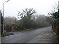
A misty Manor Road
To say the houses on the south side of Manor Road between Bracken Drive and Forest Road are opulent would be an understatement - see http://www.geograph.org.uk/photo/5264978 This was a freezing day where the early fog would eventually clear to mist but it remained bitterly cold.
Image: © Marathon
Taken: 25 Jan 2017
0.21 miles
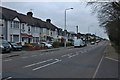
5
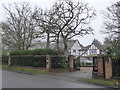
House on Manor Road
To say the houses on the south side of Manor Road between Bracken Drive and Forest Road are opulent would be an understatement.
Image: © Marathon
Taken: 25 Jan 2017
0.22 miles