IMAGES TAKEN NEAR TO
Copperfield, CHIGWELL, IG7 5LE
Introduction
This page details the photographs taken nearby to Copperfield, IG7 5LE by members of the Geograph project.
The Geograph project started in 2005 with the aim of publishing, organising and preserving representative images for every square kilometre of Great Britain, Ireland and the Isle of Man.

There are currently over 7.5m images from over14,400 individuals and you can help contribute to the project by visiting https://www.geograph.org.uk
Image Map
Images are licensed for reuse under creativecommons.org/licenses/by-sa/2.0
Notes
- Clicking on the map will re-center to the selected point.
- The higher the marker number, the further away the image location is from the centre of the postcode.
Image Listing (4 Images Found)
Images are licensed for reuse under creativecommons.org/licenses/by-sa/2.0
Image
Details
Distance
1
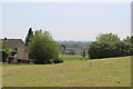
View over Romford area from the top of the hill at the top of the Limes Farm Estate
Looking south-southeast.
Image: © Robert Lamb
Taken: 28 May 2023
0.21 miles
2
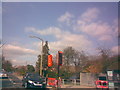
New pelican crossing on Fencepiece Road
A new pelican crossing has been erected but is not yet active on Fencepiece Road just as you cross the boundary from Redbridge into Epping Forest. Also in this shot is another grand Epping Forest concrete lamp post, albeit with a more modern low pressure sodium lantern than the one shown here: Image
Image: © Robert Lamb
Taken: 22 Mar 2009
0.24 miles
3
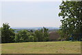
View over south London from the top of the hill at the top of the Limes Farm Estate
Looking south-southwest.
Image: © Robert Lamb
Taken: 28 May 2023
0.24 miles
4
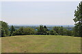
View over Ilford area from the top of the hill at the top of the Limes Farm Estate
Looking southeast.
Image: © Robert Lamb
Taken: 28 May 2023
0.25 miles