IMAGES TAKEN NEAR TO
Park View, CHIGWELL, IG7 5EF
Introduction
This page details the photographs taken nearby to Park View, IG7 5EF by members of the Geograph project.
The Geograph project started in 2005 with the aim of publishing, organising and preserving representative images for every square kilometre of Great Britain, Ireland and the Isle of Man.

There are currently over 7.5m images from over14,400 individuals and you can help contribute to the project by visiting https://www.geograph.org.uk
Image Map
Images are licensed for reuse under creativecommons.org/licenses/by-sa/2.0
Notes
- Clicking on the map will re-center to the selected point.
- The higher the marker number, the further away the image location is from the centre of the postcode.
Image Listing (24 Images Found)
Images are licensed for reuse under creativecommons.org/licenses/by-sa/2.0
Image
Details
Distance
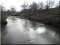
2
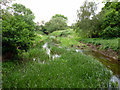
River Roding
Downstream of a bridleway bridge.
Image: © Robin Webster
Taken: 2 Jun 2012
0.13 miles
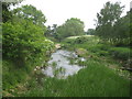
5
River Roding near Chigwell
The River Roding rises near Dunmow, then flows through Essex to form Barking Creek as it reaches the River Thames. For more information see https://en.wikipedia.org/wiki/River_Roding and http://www.londonslostrivers.com/river-roding.html and http://www.telegraph.co.uk/travel/cruises/riversandcanals/9885094/Germaine-Greer-its-time-to-take-care-of-Essexs-rivers.html and http://thelostbyway.com/tag/river-roding
This view is looking downriver from the small footbridge just south of the Central line viaduct. See http://www.geograph.org.uk/photo/5274177 for the view in the other direction.
Image: © Marathon
Taken: 6 Feb 2017
0.13 miles
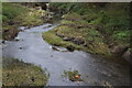
6
River Roding
Viewed looking downstream from the footbridge by Image the water level in the Roding appeared much lower than usual at this time of year, after a sustained period of dry weather during the spring of 2011.
Image: © Nigel Cox
Taken: 29 Apr 2011
0.14 miles
8
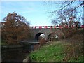
Roding Valley viaduct
Few stretches of the London tube network are as rural as the Woodford to Hainault branch of the Central Line. Here a train crosses the viaduct over the River Roding, not far from Roding Valley station. This line was built by the Eastern Counties railway in the mid nineteenth century and became part of the Central Line about a hundred years later.
Image: © John Davies
Taken: 13 Dec 2005
0.16 miles
10
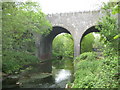
River Roding and the former Great Eastern Railway viaduct
This is the River Roding viewed looking upstream at the point at which the former Great Eastern Railway built their viaduct across the river in about 1903 for their Woodford and Ilford Branch. At the grouping of the railway companies in 1923 operations were taken over by the London & North Eastern Railway, but prior to the nationalization of the railways in 1948 responsibilities were transferred to London Underground and today Central Line trains use the viaduct.
Image: © Nigel Cox
Taken: 29 Apr 2011
0.17 miles