IMAGES TAKEN NEAR TO
High Road, CHIGWELL, IG7 5BJ
Introduction
This page details the photographs taken nearby to High Road, IG7 5BJ by members of the Geograph project.
The Geograph project started in 2005 with the aim of publishing, organising and preserving representative images for every square kilometre of Great Britain, Ireland and the Isle of Man.

There are currently over 7.5m images from over14,400 individuals and you can help contribute to the project by visiting https://www.geograph.org.uk
Image Map
Images are licensed for reuse under creativecommons.org/licenses/by-sa/2.0
Notes
- Clicking on the map will re-center to the selected point.
- The higher the marker number, the further away the image location is from the centre of the postcode.
Image Listing (56 Images Found)
Images are licensed for reuse under creativecommons.org/licenses/by-sa/2.0
Image
Details
Distance
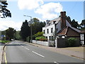
3
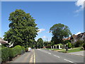
High Road, Chigwell
High Road, Chigwell, forms part of the A113.
Image: © Malc McDonald
Taken: 17 Aug 2019
0.03 miles

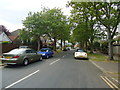
6
High Road, Chigwell
High Road in Chigwell forms part of the A113.
Image: © Malc McDonald
Taken: 17 Aug 2019
0.06 miles
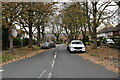
10
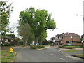
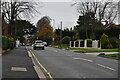
Chigwell Park
Chigwell Park is a post-war housing estate probably developed because of its proximity to Image This island of trees in the middle of the road is near the entrance to the estate on Chigwell Park Drive.
Image: © Nigel Cox
Taken: 29 Apr 2011
0.08 miles