IMAGES TAKEN NEAR TO
High Road, CHIGWELL, IG7 5BH
Introduction
This page details the photographs taken nearby to High Road, IG7 5BH by members of the Geograph project.
The Geograph project started in 2005 with the aim of publishing, organising and preserving representative images for every square kilometre of Great Britain, Ireland and the Isle of Man.

There are currently over 7.5m images from over14,400 individuals and you can help contribute to the project by visiting https://www.geograph.org.uk
Image Map
Images are licensed for reuse under creativecommons.org/licenses/by-sa/2.0
Notes
- Clicking on the map will re-center to the selected point.
- The higher the marker number, the further away the image location is from the centre of the postcode.
Image Listing (22 Images Found)
Images are licensed for reuse under creativecommons.org/licenses/by-sa/2.0
Image
Details
Distance
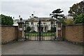
1
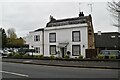
Chigwell Golf Clubhouse
Grade II listed.
Image: © N Chadwick
Taken: 20 Nov 2021
0.01 miles
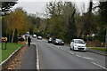
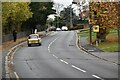
6
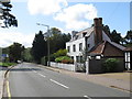
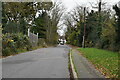
High Road, Chigwell
High Road in Chigwell forms part of the A113.
Image: © Malc McDonald
Taken: 17 Aug 2019
0.12 miles
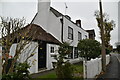
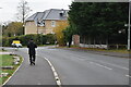
10
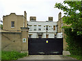
The former Great West Hatch Hospital
Until 1992 a small mental hospital, now part of a very up-market gated residential development, with the main entrance on the A113 main road.
Image: © Robin Webster
Taken: 2 Jun 2012
0.16 miles