IMAGES TAKEN NEAR TO
Englands Lane, LOUGHTON, IG10 2QT
Introduction
This page details the photographs taken nearby to Englands Lane, IG10 2QT by members of the Geograph project.
The Geograph project started in 2005 with the aim of publishing, organising and preserving representative images for every square kilometre of Great Britain, Ireland and the Isle of Man.

There are currently over 7.5m images from over14,400 individuals and you can help contribute to the project by visiting https://www.geograph.org.uk
Image Map (Loading...)


Getting Data...Please wait
Leaflet Map data © OpenStreetMap
Images are licensed for reuse under creativecommons.org/licenses/by-sa/2.0
Notes
- Clicking on the map will re-center to the selected point.
- The higher the marker number, the further away the image location is from the centre of the postcode.
Image Listing (22 Images Found)
Images are licensed for reuse under creativecommons.org/licenses/by-sa/2.0
Image
Details
Distance
6
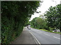
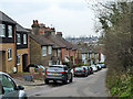
Bottom end of Lower Road, Loughton
This was the earlier road from Epping to Loughton, Woodford and London. In 1771-75 a closely parallel road, Golding's Hill, was built by the Epping and Ongar Turnpike Trust to ease the gradient up the hill. This new road remains the local main road here, although the whole lot was bypassed when Epping New Road was opened through Epping Forest in 1834, and which became the A11, now the A104. A final stage of bypass for long distance traffic (beyond Epping) was when the southern part of the M11 opened in 1977.
Image: © Robin Webster
Taken: 1 Apr 2013
0.15 miles
8
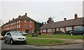
Lower Road, Loughton
This was the earlier road from Epping to Loughton, Woodford and London. In 1771-75 a closely parallel road, Golding's Hill, was built by the Epping and Ongar Turnpike Trust to ease the gradient up the hill. This new road remains the local main road here, although the whole lot was bypassed when Epping New Road was opened through Epping Forest in 1834, and which became the A11, now the A104. A final stage of bypass for long distance traffic (beyond Epping) was when the southern part of the M11 opened in 1977.
Image: © Robin Webster
Taken: 1 Apr 2013
0.16 miles