IMAGES TAKEN NEAR TO
Steeds Way, LOUGHTON, IG10 1HX
Introduction
This page details the photographs taken nearby to Steeds Way, IG10 1HX by members of the Geograph project.
The Geograph project started in 2005 with the aim of publishing, organising and preserving representative images for every square kilometre of Great Britain, Ireland and the Isle of Man.

There are currently over 7.5m images from over14,400 individuals and you can help contribute to the project by visiting https://www.geograph.org.uk
Image Map (Loading...)


Getting Data...Please wait
Leaflet Map data © OpenStreetMap
Images are licensed for reuse under creativecommons.org/licenses/by-sa/2.0
Notes
- Clicking on the map will re-center to the selected point.
- The higher the marker number, the further away the image location is from the centre of the postcode.
Image Listing (20 Images Found)
Images are licensed for reuse under creativecommons.org/licenses/by-sa/2.0
Image
Details
Distance
3
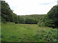
Woodbury Hollow
Looking downhill onto Woodbury Hollow
Image: © Roger Jones
Taken: 24 Jun 2011
0.12 miles
4
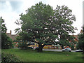
School oak
Fine oak tree, opposite Staples Road School
Image: © Roger Jones
Taken: 24 Jun 2011
0.14 miles
5
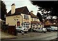
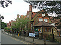
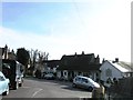
'The Wheatsheaf' public house in Loughton
Image: © Robert Edwards
Taken: 23 Jan 2009
0.14 miles
6
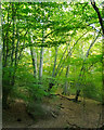
Sunlight in the canopy, Epping Forest, Loughton
Image: © Roger Jones
Taken: 7 Aug 2016
0.14 miles
9
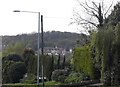
Staple's Hill, Loughton
Looking towards Epping Forest
Image: © David Howard
Taken: 9 Apr 2014
0.16 miles