IMAGES TAKEN NEAR TO
High Road, LOUGHTON, IG10 1HA
Introduction
This page details the photographs taken nearby to High Road, IG10 1HA by members of the Geograph project.
The Geograph project started in 2005 with the aim of publishing, organising and preserving representative images for every square kilometre of Great Britain, Ireland and the Isle of Man.

There are currently over 7.5m images from over14,400 individuals and you can help contribute to the project by visiting https://www.geograph.org.uk
Image Map (Loading...)


Getting Data...Please wait
Leaflet Map data © OpenStreetMap
Images are licensed for reuse under creativecommons.org/licenses/by-sa/2.0
Notes
- Clicking on the map will re-center to the selected point.
- The higher the marker number, the further away the image location is from the centre of the postcode.
Image Listing (95 Images Found)
Images are licensed for reuse under creativecommons.org/licenses/by-sa/2.0
Image
Details
Distance
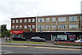
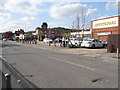
2
The Drive at the junction of High Road, Loughton
Image: © David Howard
Taken: 9 Apr 2014
0.02 miles
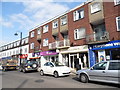
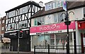
3
Morrisons car park on The Drive, Loughton
Image: © David Howard
Taken: 9 Apr 2014
0.02 miles
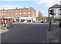
6
Royal Mail business box on High Road, Loughton
Postbox No. IG10 1113.
Image: © JThomas
Taken: 6 Jul 2019
0.06 miles
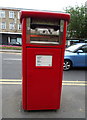
7
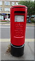
Elizabeth II postbox on High Road, Loughton
Postbox No. IG10 13.
See Image] for context.
Image: © JThomas
Taken: 6 Jul 2019
0.06 miles
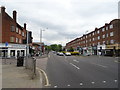
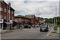
8
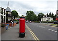
High Road, Loughton
Showing position of Postbox No. IG10 13.
See Image] for postbox.
Image: © JThomas
Taken: 6 Jul 2019
0.06 miles