IMAGES TAKEN NEAR TO
Ayre View, HEBDEN BRIDGE, HX7 8SX
Introduction
This page details the photographs taken nearby to Ayre View, HX7 8SX by members of the Geograph project.
The Geograph project started in 2005 with the aim of publishing, organising and preserving representative images for every square kilometre of Great Britain, Ireland and the Isle of Man.

There are currently over 7.5m images from over14,400 individuals and you can help contribute to the project by visiting https://www.geograph.org.uk
Image Map
Images are licensed for reuse under creativecommons.org/licenses/by-sa/2.0
Notes
- Clicking on the map will re-center to the selected point.
- The higher the marker number, the further away the image location is from the centre of the postcode.
Image Listing (76 Images Found)
Images are licensed for reuse under creativecommons.org/licenses/by-sa/2.0
Image
Details
Distance
1
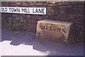
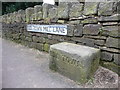
Old Guide Stone by Old Town Mill Lane, Wadsworth
Guide stone by the UC road, in parish of Wadsworth (Calderdale District), Old Town Mill Lane, Old Town, in pavement at junction with Parrock Lane.
Inscription reads:-
OLD TOWN
{<-pointing hand}
Grade II listed.
List Entry Number: 1265495 https://historicengland.org.uk/listing/the-list/list-entry/1265495
Surveyed
Milestone Society National ID: YW_XHEBe
Image: © Milestone Society
Taken: Unknown
0.02 miles
2
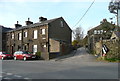
Wainsgate Lane, Old Town, Wadsworth
Image: © Humphrey Bolton
Taken: 21 Mar 2016
0.02 miles
3
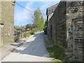
Bridleway near to Old Town
Looking northward.
Image: © Peter Wood
Taken: 11 May 2017
0.02 miles
5
Guide stone at the end of Old Town Mill Lane, Wadsworth
Image: © Humphrey Bolton
Taken: 21 Mar 2016
0.02 miles
6
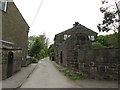
Old guidestone
North of Hebden Bridge. At the north west end of Old Town Mill Lane as it leaves Parrock Lane. Its companion is at the other end of Old Town Mill Lane where it meets Walker Lane. Grade II listed 424795.
north of Hebden Bridge.
Image: © Robert Glover
Taken: 16 Nov 2020
0.03 miles
7
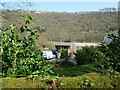
The hamlet of Boston Hill, from Lower Lee
On opposite sides of Hebden Water, but with a height difference [above sea level] of about 135 metres. About 665 metres apart.
Image: © Christine Johnstone
Taken: 30 Mar 2021
0.03 miles
8

Bridleway off Parrock lane, Old Town, Wadsworth
Image: © Humphrey Bolton
Taken: 21 Mar 2016
0.03 miles
9
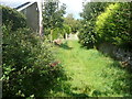
Wadsworth Bridleway 56 leaving Parrock Lane, Old Town
This is not usable as a bridleway, as there is a locked gate and stile further up.
Image: © Humphrey Bolton
Taken: 29 Aug 2018
0.04 miles
10
Wainscott Close, south of Pecket Well
Image: © Alex McGregor
Taken: 6 Jan 2011
0.05 miles