IMAGES TAKEN NEAR TO
Back Lane, HEBDEN BRIDGE, HX7 8RP
Introduction
This page details the photographs taken nearby to Back Lane, HX7 8RP by members of the Geograph project.
The Geograph project started in 2005 with the aim of publishing, organising and preserving representative images for every square kilometre of Great Britain, Ireland and the Isle of Man.

There are currently over 7.5m images from over14,400 individuals and you can help contribute to the project by visiting https://www.geograph.org.uk
Image Map
Images are licensed for reuse under creativecommons.org/licenses/by-sa/2.0
Notes
- Clicking on the map will re-center to the selected point.
- The higher the marker number, the further away the image location is from the centre of the postcode.
Image Listing (7 Images Found)
Images are licensed for reuse under creativecommons.org/licenses/by-sa/2.0
Image
Details
Distance
2
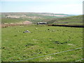
An intake field, Wadsworth
This field was probably taken from the moor in the early 19C and turned into pasture. Some boulders were left in place, so the land has evidently never been ploughed. High Greave is in the distance.
Image: © Humphrey Bolton
Taken: 9 May 2016
0.17 miles
3
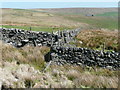
A kink in the intake wall, Wadsworth
Image: © Humphrey Bolton
Taken: 9 May 2016
0.19 miles
4
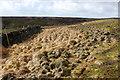
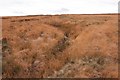
Tussocks on Flaight Hill
Uncompromising and acidic vegetation on Flaight Hill
Image: © Chris Heaton
Taken: 11 Apr 2015
0.22 miles
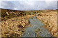
5
Stony Dike, Shackleton Moor
Looking NW up Stony Dike from SD 987 330.
Image: © Mark Anderson
Taken: 25 Nov 2005
0.22 miles
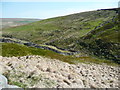
6
Shooting Track on Shackleton Moor
Gives access to the grouse butts above Calf Hey Clough
Image: © Chris Heaton
Taken: 11 Apr 2015
0.22 miles
7
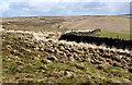
On Flaight Hill
Section of moorland composed of tight uncompromising tussocks - hard graft for the solitary walker.
Image: © Chris Heaton
Taken: 11 Apr 2015
0.24 miles