IMAGES TAKEN NEAR TO
Saughes Cottages, HEBDEN BRIDGE, HX7 8PJ
Introduction
This page details the photographs taken nearby to Saughes Cottages, HX7 8PJ by members of the Geograph project.
The Geograph project started in 2005 with the aim of publishing, organising and preserving representative images for every square kilometre of Great Britain, Ireland and the Isle of Man.

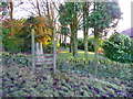
There are currently over 7.5m images from over14,400 individuals and you can help contribute to the project by visiting https://www.geograph.org.uk
Image Map
Images are licensed for reuse under creativecommons.org/licenses/by-sa/2.0
Notes
- Clicking on the map will re-center to the selected point.
- The higher the marker number, the further away the image location is from the centre of the postcode.
Image Listing (138 Images Found)
Images are licensed for reuse under creativecommons.org/licenses/by-sa/2.0
Image
Details
Distance
1
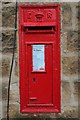
Edward VII Postbox, Wadsworth Lane
Set into the wall of a house on Wadsworth Lane, Hebden Bridge.
Image: © Mark Anderson
Taken: 6 Aug 2007
0.03 miles
2

Daisy Bank, Wadsworth Lane, Mytholmroyd
A small development up near the moors and handy for the Hebden Bridge Golf Course. Stone-faced, with mullioned windows, but not authentic to the extent of having verges, kneelers and finials on the roof gables.
Image: © Humphrey Bolton
Taken: 5 Mar 2009
0.03 miles
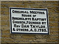
4
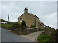
Upper Needless
Originally the meeting house of Birchcliffe Baptist Church
Image: © Alexander P Kapp
Taken: 19 May 2010
0.04 miles
5
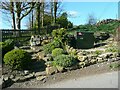
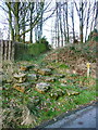
Footpath through a rockery, Wadsworth Lane, Mytholmroyd
No waymark next to the road, but there is one in sight. This area is neat and cared for now. See Image] for an earlier view.
Image: © Humphrey Bolton
Taken: 2 Apr 2023
0.04 miles
6
The Daisy Bank path, Hebden Royd FP22
The first time I looked for this path I could see no sign of it and thought it had been blocked by the housing development. However I later read in the CROWS blog that they (the Community Rights-of-Way Service) had cleared it. They found the steps and waymark pole under thick vegetation. The path is perfectly clear along the edge of the gardens of the new houses, and then goes over a stile into fields, where it crosses the parish boundary and becomes Wadsworth FP78.
Image: © Humphrey Bolton
Taken: 8 Dec 2014
0.04 miles
7
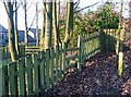
Stile on the Daisy Bank path, Hebden Royd FP22
Here the path goes into the gardens of the new houses, keeping to the edge amongst trees.
Image: © Humphrey Bolton
Taken: 8 Dec 2014
0.04 miles
8
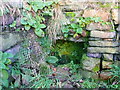
Well at Ambry Well
This is in the position, captioned 'Ambry Well', shown on the 1850 six-inch map and 1905 1:2500 map. The house nearby is now called 'St Ambrose's Well'. This name crops up in various places, often shortened as in 'Ambry', and there are schools named after him. However he was the Bishop of Milan in the fourth century, and it seems unlikely that he had anything to do with this well.
Image: © Humphrey Bolton
Taken: 8 Dec 2014
0.05 miles
9
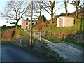
A branch of Hebden Royd FP22
There are two paths with this number. This is the Ambry (or St Ambrose's) Well path. This branch goes along the drive and meets a path that starts from the road on the corner to the left before going to the right past the houses. It then crosses Bridleway 21 and then Height Road, and goes up onto the moor. The other FP22 goes past the Daisy Bank houses and becomes Wadsworth FP78.
Image: © Humphrey Bolton
Taken: 8 Dec 2014
0.06 miles
10
Stile on the Daisy Bank path, Hebden Royd FP22
This is where the path leaves the gardens and enters a field.
Image: © Humphrey Bolton
Taken: 8 Dec 2014
0.06 miles