IMAGES TAKEN NEAR TO
HEBDEN BRIDGE, HX7 8PG
Introduction
This page details the photographs taken nearby to HX7 8PG by members of the Geograph project.
The Geograph project started in 2005 with the aim of publishing, organising and preserving representative images for every square kilometre of Great Britain, Ireland and the Isle of Man.

There are currently over 7.5m images from over14,400 individuals and you can help contribute to the project by visiting https://www.geograph.org.uk
Image Map
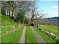
Images are licensed for reuse under creativecommons.org/licenses/by-sa/2.0
Notes
- Clicking on the map will re-center to the selected point.
- The higher the marker number, the further away the image location is from the centre of the postcode.
Image Listing (117 Images Found)
Images are licensed for reuse under creativecommons.org/licenses/by-sa/2.0
Image
Details
Distance
1
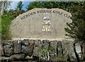
Golf Club sign, Mytholmroyd
An inscribed stone with an amusing badge, above the retaining wall at the side of Height Road.
Image: © Humphrey Bolton
Taken: 12 Jun 2010
0.03 miles
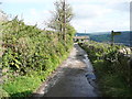
2
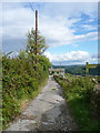
Raw Lane at footpath junction
The signpost points down Hebden Royd FP15. Raw Lane is FP21.
Image: © Humphrey Bolton
Taken: 18 Aug 2014
0.06 miles
4
The top of Hebden Royd FP15 at Raw Lane
This was shown as a walled path on the 1850 six-inch map.
Image: © Humphrey Bolton
Taken: 10 Sep 2012
0.06 miles
5
Hebden Royd FP15 at Raw Lane
The signpost points the way down to Burlees Lane.
Image: © Humphrey Bolton
Taken: 7 Oct 2013
0.06 miles
6
Gate on Hebden Royd FP15
This it at the junction of two branches of the footpath.
Image: © Humphrey Bolton
Taken: 9 Sep 2013
0.08 miles
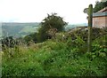
7
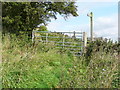
Gate and footpath signpost on Hebden Royd FP15
This it at the junction of two branch paths up from Burlees lane to Raw Lane, both numbered 15. The signpost here is not a legal requirement, but is certainly more visible than a waymark.
Image: © Humphrey Bolton
Taken: 7 Oct 2013
0.08 miles
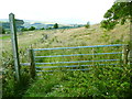
8

Gate, stile and signpost on Hebden Royd FP15
This is where the path that slants up from Burlees Cottages meets the path straight down the hillside from Raw Lane to Burlees Lane. I had not previously noticed the stile, which is hidden by grass and the signpost. The latter is a surprise, as usually at a footpath junction there are usually just waymarks.
Image: © Humphrey Bolton
Taken: 18 Aug 2014
0.08 miles
9
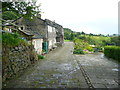
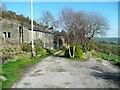
Burlees Lane at Owlers
The link for the listed building information: http://list.historicengland.org.uk/resultsingle.aspx?uid=1229025 .
Image: © Humphrey Bolton
Taken: 18 Aug 2014
0.09 miles
10
Lane to Owlers and Stephenson House
Image: © Humphrey Bolton
Taken: 2 Apr 2023
0.09 miles