IMAGES TAKEN NEAR TO
Bethel Terrace, HEBDEN BRIDGE, HX7 8HT
Introduction
This page details the photographs taken nearby to Bethel Terrace, HX7 8HT by members of the Geograph project.
The Geograph project started in 2005 with the aim of publishing, organising and preserving representative images for every square kilometre of Great Britain, Ireland and the Isle of Man.

There are currently over 7.5m images from over14,400 individuals and you can help contribute to the project by visiting https://www.geograph.org.uk
Image Map
Images are licensed for reuse under creativecommons.org/licenses/by-sa/2.0
Notes
- Clicking on the map will re-center to the selected point.
- The higher the marker number, the further away the image location is from the centre of the postcode.
Image Listing (135 Images Found)
Images are licensed for reuse under creativecommons.org/licenses/by-sa/2.0
Image
Details
Distance
1
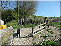
Hebden Royd FP7 (5), at Hurst Road, Hebden Bridge
The path turns right along the road. The path straight forward is Wadsworth FP81.
Image: © Humphrey Bolton
Taken: 21 Apr 2015
0.02 miles
2
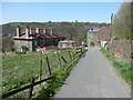
Hebden Royd FP7 (6) on Hurst Road, Hebden Bridge
The rows of houses in this image are in rather different styles, but both were built between 1894 and 1907. The row on the right is Bethel Terrace. The houses in the row on the left are 'throughs' despite the symmetrical window and chimney arrangement in the end wall.
Image: © Humphrey Bolton
Taken: 21 Apr 2015
0.03 miles
3
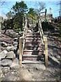
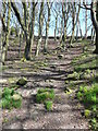
Hebden Royd FP7 (4), steps at the top of Joan Wood, Hebden Bridge
New-looking wooden steps unusual in being supported by brickwork.
Image: © Humphrey Bolton
Taken: 21 Apr 2015
0.04 miles
4
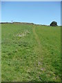
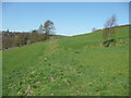
Wadsworth FP81
This path follows the line of a former field boundary.
Image: © Humphrey Bolton
Taken: 21 Apr 2015
0.07 miles
5
Hebden Royd FP7 (3) in Joan Wood, Hebden bridge
The wood was called 'John Wood' on old OS maps, eg the 1894 1:2500 map.
Image: © Humphrey Bolton
Taken: 21 Apr 2015
0.07 miles

7
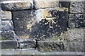
Benchmark on stone in wall on east side of Keighley Road opposite Lee Mill Road
Ordnance Survey cut mark benchmark described on the Bench Mark Database at www.bench-marks.org.uk/bm70178
Image: © Luke Shaw
Taken: 28 Aug 2017
0.07 miles
8
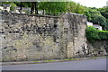
Walls on east side of Keighley Road opposite Lee Mill Road junction
There is an Ordnance Survey benchmark Image on a stone at the base of the right hand edge of the highest section of the wall
Image: © Luke Shaw
Taken: 28 Aug 2017
0.07 miles
9
Wadsworth FP81, branch to FP80
A field path following the line of a former field boundary.
Image: © Humphrey Bolton
Taken: 21 Apr 2015
0.09 miles
10
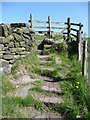
Wadsworth FP81, stile
This is at the top of a steep path up from Hurst Road.
Image: © Humphrey Bolton
Taken: 21 Apr 2015
0.09 miles