IMAGES TAKEN NEAR TO
St. Johns Close, HEBDEN BRIDGE, HX7 8DP
Introduction
This page details the photographs taken nearby to St. Johns Close, HX7 8DP by members of the Geograph project.
The Geograph project started in 2005 with the aim of publishing, organising and preserving representative images for every square kilometre of Great Britain, Ireland and the Isle of Man.

There are currently over 7.5m images from over14,400 individuals and you can help contribute to the project by visiting https://www.geograph.org.uk
Image Map
Images are licensed for reuse under creativecommons.org/licenses/by-sa/2.0
Notes
- Clicking on the map will re-center to the selected point.
- The higher the marker number, the further away the image location is from the centre of the postcode.
Image Listing (748 Images Found)
Images are licensed for reuse under creativecommons.org/licenses/by-sa/2.0
Image
Details
Distance
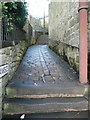
2
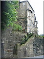
The Stubbing Footpath, Stoney Lane or Bankside
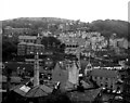
This path has three names. See also Image The building on the left was St John's Church, completed in 1931 and closed in 1984, and then converted to houses.
Image: © Humphrey Bolton
Taken: 15 Dec 2014
0.01 miles
4
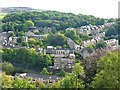
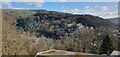
Hebden Bridge
A view east from the minor road which leads uphill and north from Hebden Bridge towards Hardcastle Crags. The houses are to the north-east of Hebden Bridge town centre.
Image: © G Laird
Taken: 19 Sep 2017
0.02 miles
5
Hebden Bridge, Yorkshire
A view over the central and eastern parts of the town, taken from the old road to Heptonstall.
Image: © Dr Neil Clifton
Taken: 15 Aug 1977
0.02 miles
6
Across Hebden Bridge to Birchcliffe
Looking from Heptonstall Road towards the Birchcliffe hillside.
Image: © NigglePics
Taken: 23 Feb 2023
0.02 miles
7
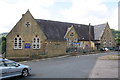
Stubbings Infant and Nursery School with access steps from School Street
There is an Ordnance Survey benchmark Image on the wall angle on the left hand side of the entrance to the steps
Image: © Roger Templeman
Taken: 12 Aug 2017
0.03 miles
8
Stubbings Infant and Nursery School, School Street
There is an Ordnance Survey benchmark Image on the right hand end of the jut at its junction with a low wall topped by railings
Image: © Roger Templeman
Taken: 12 Aug 2017
0.03 miles
9
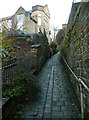
The bottom end of the Stubbing Footpath, Hebden Bridge
This is Stoney Lane, and also has the name plate 'Bankside'. It is the old highway (for packhorses) from Keighley (via Sandy gate) and Halifax (via Wadsworth Lane). It might have originally been wider before it was replaced by the turnpike roads, and by Birchcliffe Road for local traffic.
Image: © Humphrey Bolton
Taken: 15 Dec 2014
0.03 miles
10
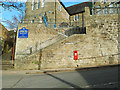
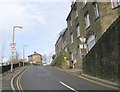
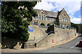
Bankside, Hebden Bridge - bottom
To the left of this imposing school building, Bankside (a stone surfaced footpath) rises steeply. There is a Georgian postbox in the wall.
Image: © Stephen Craven
Taken: 16 Feb 2019
0.03 miles