IMAGES TAKEN NEAR TO
Sunnybank, HEBDEN BRIDGE, HX7 7HG
Introduction
This page details the photographs taken nearby to Sunnybank, HX7 7HG by members of the Geograph project.
The Geograph project started in 2005 with the aim of publishing, organising and preserving representative images for every square kilometre of Great Britain, Ireland and the Isle of Man.

There are currently over 7.5m images from over14,400 individuals and you can help contribute to the project by visiting https://www.geograph.org.uk
Image Map
Images are licensed for reuse under creativecommons.org/licenses/by-sa/2.0
Notes
- Clicking on the map will re-center to the selected point.
- The higher the marker number, the further away the image location is from the centre of the postcode.
Image Listing (23 Images Found)
Images are licensed for reuse under creativecommons.org/licenses/by-sa/2.0
Image
Details
Distance
1
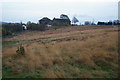
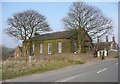
Popples Common
Looking across the unenclosed common to Mount Zion Baptist Chapel. The chapel itself is the large building on the left; this now has a new lease of life as Slack Top Centre - an evangelical Christian centred holiday centre. The building to the right is the former Sunday School which is in separate private ownership.
Image: © Phil Champion
Taken: 5 Nov 2006
0.09 miles
2
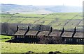
Above Long Edges
Looking over the rooftops of the terrace of Long Edges to the west of Slack. The view is southwards towards distant Stoodley Pike.
Image: © Gordon Hatton
Taken: 25 Mar 2017
0.15 miles
3
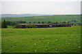
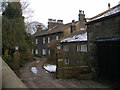
Terraced row near Slack
The terraced cottages are on Smithwell Lane and viewed from Back Lane.
Image: © Bill Boaden
Taken: 13 Jun 2015
0.15 miles
4
Mount Zion Baptist Chapel, Slack
Looking SW from Widdop Road.
Image: © Mark Anderson
Taken: 21 Aug 2005
0.18 miles
5
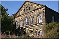
Baptist Sunday School, Slack, Heptonstall
Built by subscription in 1868.
Image: © Humphrey Bolton
Taken: 24 Mar 2011
0.18 miles
6
Doorway of Baptist Sunday School, Slack, Heptonstall
Image: © Humphrey Bolton
Taken: 24 Mar 2011
0.18 miles
7
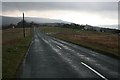
Slack
Looking down the road to Heptonstall. The Methodist chapel can be seen towards the top left of pic.
Image: © Steve Partridge
Taken: 9 Mar 2008
0.18 miles
9
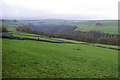
Enclosed pasture above Hebden Dale
The wooded valley hides Hebden water and comprises the National Trust's Hardcastle Crags estate. The valley is good deal deeper than it appears in this photo. The farm to the top right on the far side of the valley is Mansfield House Farm: http://www.geograph.org.uk/photo/72786
Image: © Phil Champion
Taken: 5 Nov 2006
0.20 miles
10
Mount Zion Baptist Chapel (Evangelical) Slack
Image: © Alexander P Kapp
Taken: 19 Jan 2009
0.21 miles