IMAGES TAKEN NEAR TO
Slack Top, HEBDEN BRIDGE, HX7 7HA
Introduction
This page details the photographs taken nearby to Slack Top, HX7 7HA by members of the Geograph project.
The Geograph project started in 2005 with the aim of publishing, organising and preserving representative images for every square kilometre of Great Britain, Ireland and the Isle of Man.

There are currently over 7.5m images from over14,400 individuals and you can help contribute to the project by visiting https://www.geograph.org.uk
Image Map
Images are licensed for reuse under creativecommons.org/licenses/by-sa/2.0
Notes
- Clicking on the map will re-center to the selected point.
- The higher the marker number, the further away the image location is from the centre of the postcode.
Image Listing (64 Images Found)
Images are licensed for reuse under creativecommons.org/licenses/by-sa/2.0
Image
Details
Distance
1
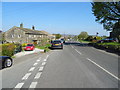
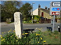
National Cycle Route 68, Slack
Looking south east.
Image: © JThomas
Taken: 19 Apr 2019
0.02 miles
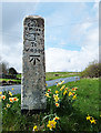
2
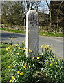
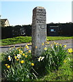
Old Milestone at the junction of Slack Road and Widdop Road
Inscription reads - To Burnley 11 Miles.
See Image] for context.
Image: © JThomas
Taken: 19 Apr 2019
0.02 miles
3
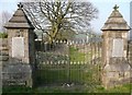
Entrance to the Baptist Cemetery, Slack, Heptonstall
The plaque on the left reads "The ground for this cemetery was presented in 1887 to the Heptonstall Slack Baptist Church by John Sutcliffe Esq. Slack House". On the right "This cemetery was extended in 1927 and the new ground (part of the original gift) was dedicated on August 14th of that year.".
Image: © Humphrey Bolton
Taken: 24 Mar 2011
0.02 miles
4
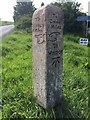
Old Milestone by Slack Bottom, Heptonstall Parish
By the UC road, in parish of Heptonstall (Calderdale District), Slack, North West of Hebden Bridge, at junction of Slack Bottom with Widdop Road, on grass at junction. Featured in a painting https://www.acgallery.co.uk/peter-brook/waiting-to-cross
Inscription reads:-
: TO / BURNLY / 11 Miles / {pointing hand} : : To / Colne / 11 Miles / {pointing hand} / TO / WIDDOP : : TO Halifax 8½ Miles / To Heptonstall ¾ Mile / {pointing hand} : : TO Halifax 8½ Miles / To Heptonstall ¾ Mile / {pointing hand} :
Carved bench mark on North East face.
Grade II listed. List Entry Number: 1226264
https://historicengland.org.uk/listing/the-list/list-entry/1226264
Surveyed
Milestone Society National ID: YW_XHEPb
Image: © Milestone Society
Taken: 1 Jan 2016
0.02 miles
5
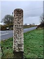
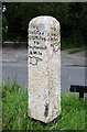
Old Milestone at the junction of Slack Road and Widdop Road
Inscription reads - To Halifax 8 1/2 Miles / To Heptonstall 1/4 Miles.
See Image] for context.
Image: © JThomas
Taken: 19 Apr 2019
0.02 miles
6
Old Milestone at the junction of Slack Road and Widdop Road
Image: © JThomas
Taken: 19 Apr 2019
0.02 miles
7
Old Milestone at the junction of Slack Road and Widdop Road
Inscription reads - To Halifax 8 1/2 Miles / To Heptonstall 1/4
Miles.
See Image] for context.
Image: © JThomas
Taken: 19 Apr 2019
0.02 miles
8
Old milestone at Slack
At Slack, northwest of Heptonstall at the Widdop Road junction. The paint on the stone is being weathered away.
This shows the northeast face To / Colne / 11 Miles / {hand pointing right} / To / WIDDOP / benchmark.
On the southwest face is To / Halifax / 8½ Miles / To / Heptonstall / ¼ Mile / {hand pointing right}.
On the southeast face is To / BURNLY / 11 Miles / {hand pointing left}.
Modern signs nearby say Burnley 10, Colne 9.
Grade II listed 423455.
Image: © Robert Glover
Taken: 10 Nov 2020
0.02 miles
9
Benchmark on a milestone
This is the northeast face of a distinctive milestone at the junction of Smithy Lane and Widdop Lane. A large OS benchmark has been carved in the centre. The road that is visible is Smithy Lane.
Image: © michael ely
Taken: 1 May 2008
0.03 miles
10
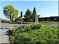
Guidepost in Slack
Image shows a location view of the stone
Image: © Roger Templeman
Taken: 28 Aug 2017
0.03 miles