IMAGES TAKEN NEAR TO
Lee Mill Road, HEBDEN BRIDGE, HX7 7AB
Introduction
This page details the photographs taken nearby to Lee Mill Road, HX7 7AB by members of the Geograph project.
The Geograph project started in 2005 with the aim of publishing, organising and preserving representative images for every square kilometre of Great Britain, Ireland and the Isle of Man.

There are currently over 7.5m images from over14,400 individuals and you can help contribute to the project by visiting https://www.geograph.org.uk
Image Map
Images are licensed for reuse under creativecommons.org/licenses/by-sa/2.0
Notes
- Clicking on the map will re-center to the selected point.
- The higher the marker number, the further away the image location is from the centre of the postcode.
Image Listing (75 Images Found)
Images are licensed for reuse under creativecommons.org/licenses/by-sa/2.0
Image
Details
Distance
1
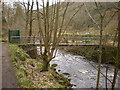
Footbridge across Hebden Water to the bowling green below Lee Mill Bridge
Image: © Alexander P Kapp
Taken: 16 Feb 2009
0.03 miles
2
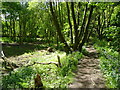
The Foster Mill Dam permissive footpath, Hebden Bridge
The path is along the dam wall. One of the two millponds, which are now empty, is on the left.
Image: © Humphrey Bolton
Taken: 23 May 2017
0.04 miles
3
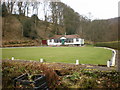
Bowling green below Lee Mill Bridge
Image: © Alexander P Kapp
Taken: 16 Feb 2009
0.05 miles
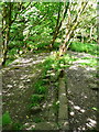
4
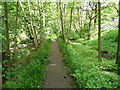
Permissive footpath between Hebden Water and the Foster Mill Goit
This path goes past the weir (Image]) to Lee Mill Road.
Image: © Humphrey Bolton
Taken: 23 May 2017
0.06 miles
5
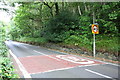
A6033 north heading towards Pecket Well
There is an Ordnance Survey benchmark Image on a stone at the base of the roadside wall right of the lamppost carrying 40mph and 20mph speed limit signs
Image: © Luke Shaw
Taken: 28 Aug 2017
0.06 miles
6
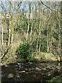
Trees and houses above Hebden Water
The houses are on Midgehole Lane.
Image: © Christine Johnstone
Taken: 30 Mar 2021
0.07 miles
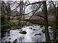
7
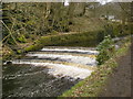
Weir on Hebden Water below Lee Mill Bridge
Image: © Alexander P Kapp
Taken: 16 Feb 2009
0.07 miles
8
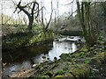
Stone wall on the east bank of Hebden Water
A retaining wall for the mill pond of Foster Mill. The pond was long and narrow, following the course of the east bank.
Image: © Christine Johnstone
Taken: 30 Mar 2021
0.07 miles
10
Overflow from the Foster Mill Dams
When the overflow was operating there would have been a waterfall down to Hebden Water.
Image: © Humphrey Bolton
Taken: 23 May 2017
0.07 miles