IMAGES TAKEN NEAR TO
HEBDEN BRIDGE, HX7 6PR
Introduction
This page details the photographs taken nearby to HX7 6PR by members of the Geograph project.
The Geograph project started in 2005 with the aim of publishing, organising and preserving representative images for every square kilometre of Great Britain, Ireland and the Isle of Man.

There are currently over 7.5m images from over14,400 individuals and you can help contribute to the project by visiting https://www.geograph.org.uk
Image Map
Images are licensed for reuse under creativecommons.org/licenses/by-sa/2.0
Notes
- Clicking on the map will re-center to the selected point.
- The higher the marker number, the further away the image location is from the centre of the postcode.
Image Listing (130 Images Found)
Images are licensed for reuse under creativecommons.org/licenses/by-sa/2.0
Image
Details
Distance
1

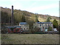
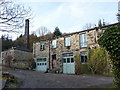
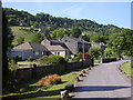
Jumble Hole Mill, Eastwood, Doorway
Image: © Alexander P Kapp
Taken: 2 Mar 2010
0.01 miles
7
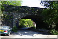
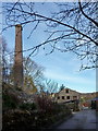
Railway Bridge, Jumble Hole Road, Eastwood, Calderdale
Image: © Robert Wade
Taken: 22 Jun 2010
0.06 miles
8
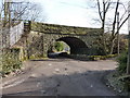
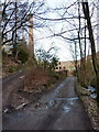
Railway bridge over Jumble Hole Road
Image: © Alexander P Kapp
Taken: 2 Mar 2010
0.07 miles
9
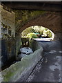
Underneath railway bridge over Jumble Hole Road
Image: © Alexander P Kapp
Taken: 2 Mar 2010
0.07 miles
10
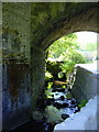
Stream under the Railway Bridge, Jumble Hole Road, Eastwood, Calderdale
The stream runs under Halifax Road into the River Calder
Image: © Robert Wade
Taken: 22 Jun 2010
0.09 miles