IMAGES TAKEN NEAR TO
Trinity Street, HEBDEN BRIDGE, HX7 6LP
Introduction
This page details the photographs taken nearby to Trinity Street, HX7 6LP by members of the Geograph project.
The Geograph project started in 2005 with the aim of publishing, organising and preserving representative images for every square kilometre of Great Britain, Ireland and the Isle of Man.

There are currently over 7.5m images from over14,400 individuals and you can help contribute to the project by visiting https://www.geograph.org.uk
Image Map
Images are licensed for reuse under creativecommons.org/licenses/by-sa/2.0
Notes
- Clicking on the map will re-center to the selected point.
- The higher the marker number, the further away the image location is from the centre of the postcode.
Image Listing (239 Images Found)
Images are licensed for reuse under creativecommons.org/licenses/by-sa/2.0
Image
Details
Distance
1
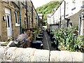
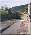
Hebden Bridge: between Eton and Cambridge
The back alley of two terraces sandwiched between the Rochdale Canal and the River Calder. Viewed from the canal towpath, Eton Street is to the left and Cambridge Street to the right
Image: © Graham Hogg
Taken: 26 Aug 2014
0.01 miles

3
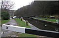
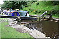
Rochdale Canal Lock 10
This is Stubbings Lower Lock on the outskirts of Hebden Bridge.
Image: © michael ely
Taken: 15 Jan 2015
0.02 miles
4
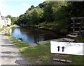
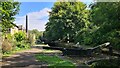
The Rochdale Canal above Hebden Bridge
The short stretch between Stubbing Locks, nos. 10 & 11
Image: © Graham Hogg
Taken: 26 Aug 2014
0.02 miles
5
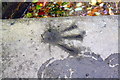
Benchmark near lock gate at west end of Rochdale Canal lock
Ordnance Survey rivet benchmark described on the Bench Mark Database at www.bench-marks.org.uk/bm59772
Image: © Roger Templeman
Taken: 19 Aug 2017
0.02 miles
7

Hebden Bridge
Seen from the west. The Rochdale Canal is to the right beside the railway line. The water to the left is the River Calder.
To the left of that are some of the "upstairs-downstairs" houses known as over and under dwellings which are typical of the town. These are 4 or 5 storey terraces. The upper storeys face uphill while the lower ones face downhill with their back wall against the hillside. The bottom 2 storeys are one house while the upper 2 - 3 storeys are another. This has led to unusual legal arrangements such as the "flying freehold", where the shared floor/ceiling is wholly owned by the underdwelling.
Image: © John Illingworth
Taken: 4 Mar 2009
0.02 miles
8
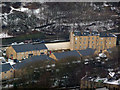
Mytholm Close and Bankfoot Terrace, Hebden Bridge
Mytholm Close was built on the site of medium rise tower blocks, in response to local demand for family accommodation. http://www.watsonbatty.com/case_residential_mytholm.html Bankfoot Terrace is a row of over and under dwellings from a century earlier.
Image: © Phil Champion
Taken: 21 Feb 2010
0.02 miles
9
West end of Rochdale Canal lock
There are two Ordnance Survey rivet benchmarks on the top surface of lock wall: one just past the lock gate Image; the other on the corner of the jut Image
Image: © Roger Templeman
Taken: 19 Aug 2017
0.02 miles
10
The Rochdale Canal, empty
The canal drained for maintenance work at Hebble End.
Image: © Stephen Craven
Taken: 8 Mar 1998
0.03 miles