IMAGES TAKEN NEAR TO
HEBDEN BRIDGE, HX7 6JF
Introduction
This page details the photographs taken nearby to HX7 6JF by members of the Geograph project.
The Geograph project started in 2005 with the aim of publishing, organising and preserving representative images for every square kilometre of Great Britain, Ireland and the Isle of Man.

There are currently over 7.5m images from over14,400 individuals and you can help contribute to the project by visiting https://www.geograph.org.uk
Image Map
Images are licensed for reuse under creativecommons.org/licenses/by-sa/2.0
Notes
- Clicking on the map will re-center to the selected point.
- The higher the marker number, the further away the image location is from the centre of the postcode.
Image Listing (318 Images Found)
Images are licensed for reuse under creativecommons.org/licenses/by-sa/2.0
Image
Details
Distance
1
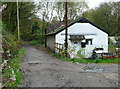
Crow Nest Road
The brick building behind the bungalow is the one in Image
Image: © Humphrey Bolton
Taken: 27 Oct 2014
0.00 miles
2
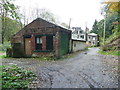
Industrial building on Crow Nest Road
Old maps suggest that there were industrial premises along this road, but apart from the gas works there is no clue as to what the industry was.
Image: © Humphrey Bolton
Taken: 27 Oct 2014
0.01 miles
3
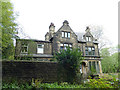
Crow Nest House, Crow Nest Road
There are two houses here, the one on the left was for sale when this image was taken.
Image: © Humphrey Bolton
Taken: 27 Oct 2014
0.03 miles
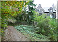
4
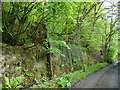
Ruins alongside Crow Nest Road
There used to be a gas works across the road, and the 1907 map shows "tanks" on this side, of which this may be the remains.
Image: © Stephen Craven
Taken: 11 May 2019
0.03 miles
6
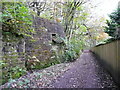
Structure above Crow Nest Road
This is opposite the site of the old gas works, and my guess is that it was a store for coal, which was perhaps delivered from Wood Top Road above.
Image: © Humphrey Bolton
Taken: 27 Oct 2014
0.04 miles
7
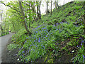
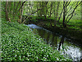
Bluebells alongside the cycle route
The path, on the south bank of the river, is part of the Trans Pennine Trail. The trees are growing on a railway embankment.
Image: © Stephen Craven
Taken: 11 May 2019
0.06 miles
8
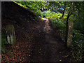
Crow Nest Road (footpath), Hebden Bridge
Looking north west towards Crow Nest Cottage. This public footpath runs along the bottom of Crow Nest Wood, next to the railway line.
Image: © Phil Champion
Taken: 2 Sep 2005
0.06 miles
9
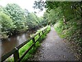
Cycle path alongside the River Calder
Image: © Humphrey Bolton
Taken: 3 Sep 2012
0.06 miles