IMAGES TAKEN NEAR TO
Church View, HEBDEN BRIDGE, HX7 6DN
Introduction
This page details the photographs taken nearby to Church View, HX7 6DN by members of the Geograph project.
The Geograph project started in 2005 with the aim of publishing, organising and preserving representative images for every square kilometre of Great Britain, Ireland and the Isle of Man.

There are currently over 7.5m images from over14,400 individuals and you can help contribute to the project by visiting https://www.geograph.org.uk
Image Map
Images are licensed for reuse under creativecommons.org/licenses/by-sa/2.0
Notes
- Clicking on the map will re-center to the selected point.
- The higher the marker number, the further away the image location is from the centre of the postcode.
Image Listing (117 Images Found)
Images are licensed for reuse under creativecommons.org/licenses/by-sa/2.0
Image
Details
Distance
1
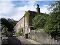
Brookside
A block of terrace houses, on the site of Eaves Mill, which was substantially constructed from materials re-used after the demolition of the Mill.
Image: © Michael Steele
Taken: 2 May 2011
0.01 miles
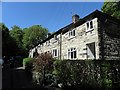
3
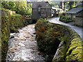
Mill ponds below Eaves Wood
The two mill ponds or reservoirs to the left and right of the photo were constructed to supply Eaves Mills. The mills were probably constructed about 1830 and were demolished around 1925 after the estate had been purchased by the Urban District Council, who also built the houses below the mill ponds.
Image: © Phil Champion
Taken: 20 Mar 2008
0.05 miles
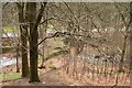
5
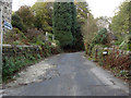
Colden Road, Mytholm
A lovely bridleway that follows the Colden Water valley to Jack Bridge.
Image: © michael ely
Taken: 1 Nov 2008
0.07 miles
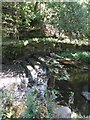
6
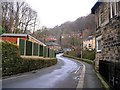
Colden Water, looking downstream from Eaves Road
Image: © Phil Champion
Taken: 3 Oct 2010
0.07 miles
8
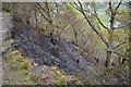
Result of fire in Eaves Wood
During the dry spring of 2007 there have been several outbreaks of fire in Eaves wood and the adjoining grassland along the edge below Heptonstall. This fire has ripped through the ground cover and turned the freshly unfurled, bright green leaves of the trees a crispy brown. The affected patch is visible from the opposite side of the Colden Valley .
Image: © Phil Champion
Taken: 4 May 2007
0.08 miles
9
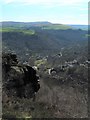
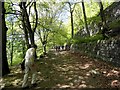
Gritstone crag above Hebden Bridge
The Calderdale Way passes these craggy outcrops above Eaves Wood. The view into the valley encompasses the Mytholm end of Hebden Bridge. Stoodly Pike stands on the skyline.
Image: © Gordon Hatton
Taken: 25 Mar 2017
0.09 miles