IMAGES TAKEN NEAR TO
Cragg Road, HEBDEN BRIDGE, HX7 5SS
Introduction
This page details the photographs taken nearby to Cragg Road, HX7 5SS by members of the Geograph project.
The Geograph project started in 2005 with the aim of publishing, organising and preserving representative images for every square kilometre of Great Britain, Ireland and the Isle of Man.

There are currently over 7.5m images from over14,400 individuals and you can help contribute to the project by visiting https://www.geograph.org.uk
Image Map
Images are licensed for reuse under creativecommons.org/licenses/by-sa/2.0
Notes
- Clicking on the map will re-center to the selected point.
- The higher the marker number, the further away the image location is from the centre of the postcode.
Image Listing (171 Images Found)
Images are licensed for reuse under creativecommons.org/licenses/by-sa/2.0
Image
Details
Distance
1
The bottom of Hebden Royd FP114
At the junction with Cragg Road.
Image: © Humphrey Bolton
Taken: 8 Jul 2013
0.02 miles
2
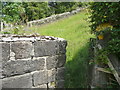
Gate on Hebden Royd FP114
This little gate is where the path enters a field and turns left across the bottom end of it.
Image: © Humphrey Bolton
Taken: 8 Jul 2013
0.02 miles
3
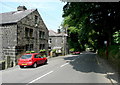
Cragg Road at the top of the footpath from Castle Gate
The path starts in the narrow space between the stone post and the outbuilding to the left of the nearest red car. The public footpath sign is attached to the pole of the bus stop sign on the right. However the path is not on the definitive map of rights-of-way.
Image: © Humphrey Bolton
Taken: 8 Jul 2013
0.02 miles
4
On the footpath from Castle Gate to Cragg Road
Looking up the last part of the path before Cragg Road is reached.
Image: © Humphrey Bolton
Taken: 8 Jul 2013
0.02 miles
5
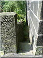
The top of the footpath up from Castle Gate
The entrance from Cragg Road is very narrow.
Image: © Humphrey Bolton
Taken: 8 Jul 2013
0.02 miles
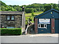
6
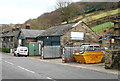
Cragg Builders, Cragg Road, Cragg Vale
Image: © Humphrey Bolton
Taken: 9 Dec 2013
0.03 miles
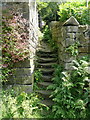
7
Narrow path off Castle Gate
This leads to Cragg Road. It is not on the map as a right-of-way, but the worn steps suggest that it has been well used in the past, probably by workers at Castle Mills.
Image: © Humphrey Bolton
Taken: 13 Dec 2011
0.03 miles
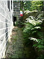
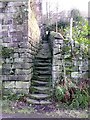
8
Bottom end of footpath to Cragg Road
This narrow path, seen here from Castle Gate, has two flights of stone steps. It is signposted at each end as a public footpath but is not on the definitive map of rights-of-way. Image is an earlier image taken from the same position.
Image: © Humphrey Bolton
Taken: 8 Jul 2013
0.03 miles
9
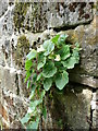
Mystery plant in footpath off Cragg Road
This is similar to Mimulus guttatus, the Monkey Flower, but that plant should be growing by a stream, not on a wall. Also the flowers are paler, and the leaves rounder at the end.
Image: © Humphrey Bolton
Taken: 8 Jul 2013
0.03 miles
10
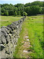
Flag stones on Hebden Royd FP114
This was evidently an important path long ago, although the path is not shown on this route on the 1850 map, but instead slanted up the hillside.
Image: © Humphrey Bolton
Taken: 8 Jul 2013
0.03 miles