IMAGES TAKEN NEAR TO
Heights Road, HEBDEN BRIDGE, HX7 5RR
Introduction
This page details the photographs taken nearby to Heights Road, HX7 5RR by members of the Geograph project.
The Geograph project started in 2005 with the aim of publishing, organising and preserving representative images for every square kilometre of Great Britain, Ireland and the Isle of Man.

There are currently over 7.5m images from over14,400 individuals and you can help contribute to the project by visiting https://www.geograph.org.uk
Image Map
Images are licensed for reuse under creativecommons.org/licenses/by-sa/2.0
Notes
- Clicking on the map will re-center to the selected point.
- The higher the marker number, the further away the image location is from the centre of the postcode.
Image Listing (74 Images Found)
Images are licensed for reuse under creativecommons.org/licenses/by-sa/2.0
Image
Details
Distance
1
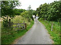
Diversion of Hebden Royd FP25 at Wicken Hill
The 1850 map and the rights-of-way map show the path going straight up the drive and continuing past the house. It has been diverted around the curtilage of the house, passing through the gate on the left. See Image for a close view of the gate.
Image: © Humphrey Bolton
Taken: 14 Jul 2014
0.02 miles
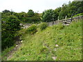
2
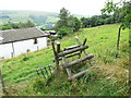
Stile on Hebden Royd FP25 above Wicken Hill
Image: © Humphrey Bolton
Taken: 19 Aug 2013
0.03 miles
3
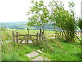
Gate on Hebden Royd FP25 below Wicken Hill
The path skirts round the house, and then joins the driveway.
Image: © Humphrey Bolton
Taken: 19 Aug 2013
0.03 miles
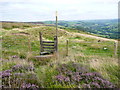
4
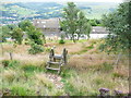
Stile on Hebden Royd FP25 above Wicken Hill
This is where the footpath leaves the access land.
Image: © Humphrey Bolton
Taken: 19 Aug 2013
0.04 miles
5
Stile on Hebden Royd FP25
Although it looks to have been improved from moorland, the field is part of the access land.
Image: © Humphrey Bolton
Taken: 19 Aug 2013
0.04 miles
6
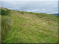
Hebden Royd FPs 25 and 29
Footpath 25 slants up to the left, and 29 goes invisibly straight forward. FP25 is an old path, shown on the 1850 six-inch map, and is slightly terraced. It would have been the way from Wicken Hill up onto Wadsworth Moor.
Image: © Humphrey Bolton
Taken: 14 Jul 2014
0.05 miles
7
Stile on Hebden Royd FP26
Although there are three waymark discs, only one of them is for a public footpath shown on the OS map.
Image: © Humphrey Bolton
Taken: 19 Aug 2013
0.07 miles
8
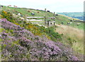
Green on Mount Skip Golf Course
This is the course of Hebden Bridge Golf Club. You don't find many greens at an altitude of 350m.
Image: © Humphrey Bolton
Taken: 19 Aug 2013
0.07 miles
9
Hebden Royd FP25 on the driveway to Wicken Hill off Height Road
Wicken Hill and this driveway are shown on the 1850 six-inch map.
Image: © Humphrey Bolton
Taken: 14 Jul 2014
0.08 miles
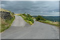
10
Stile on Hebden Royd FP30 at Height Road
Image: © Humphrey Bolton
Taken: 14 Jul 2014
0.09 miles