IMAGES TAKEN NEAR TO
Midgley Road, HEBDEN BRIDGE, HX7 5QT
Introduction
This page details the photographs taken nearby to Midgley Road, HX7 5QT by members of the Geograph project.
The Geograph project started in 2005 with the aim of publishing, organising and preserving representative images for every square kilometre of Great Britain, Ireland and the Isle of Man.

There are currently over 7.5m images from over14,400 individuals and you can help contribute to the project by visiting https://www.geograph.org.uk
Image Map
Images are licensed for reuse under creativecommons.org/licenses/by-sa/2.0
Notes
- Clicking on the map will re-center to the selected point.
- The higher the marker number, the further away the image location is from the centre of the postcode.
Image Listing (77 Images Found)
Images are licensed for reuse under creativecommons.org/licenses/by-sa/2.0
Image
Details
Distance
1

Path and driveway junction, Mytholmroyd
To the left, the driveway to Throstle Bower and Hebden Royd FP32. To the right, Dark Lane, which is Hebden Royd FP33.
Image: © Humphrey Bolton
Taken: 8 Sep 2011
0.04 miles
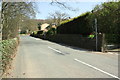
2
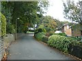
Midgley Road, Mytholmroyd
Suburban development has spread up the steep hillside.
Image: © Humphrey Bolton
Taken: 16 Oct 2008
0.05 miles
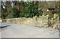
3
Midgley Road at Dark Lane junction
There is an OS benchmark Image on the further stone post embedded in the stone wall on the right hand side of the road
Image: © Luke Shaw
Taken: 21 Apr 2018
0.05 miles
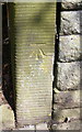
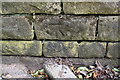
4
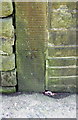
Benchmark on stone post in wall on SE side of Midgley Road
Image: © Luke Shaw
Taken: 21 Apr 2018
0.06 miles
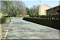
5
Looking west along Midgley Road
There is an OS benchmark Image on the gatepost at the right hand side of the gateway for the path near the right hand edge of the image
Image: © Luke Shaw
Taken: 21 Apr 2018
0.06 miles
6
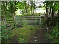
Junction of Hebden Royd FPs 32 and 33
FP33 goes over the stile to the left, and through the woodland alongside Foster Clough to a crossing of the stream. FP32 goes over the stile to the right into the narrow, sunken, Dark Lane. The gate just leads into a field.
Image: © Humphrey Bolton
Taken: 19 Aug 2013
0.07 miles
7
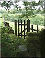
Stile and gate on Hebden Royd FP32
This footpath is shown on the 1850 six-inch map. The main FP32 is a walled path, and this branch is a field path that curves round to Dark lane via a crossing of Foster Clough. The stile has become too dilapidated to contain farm animals, so a short fence and footpath gate has been added.
Image: © Humphrey Bolton
Taken: 10 Sep 2012
0.08 miles
8
Midgley Road at Hullett Close junction
There is an OS benchmark Image on the right hand roadside wall near the road sign pole at the junction
Image: © Luke Shaw
Taken: 21 Apr 2018
0.08 miles
9
Benchmark on stone gatepost on north side of Midgley Road
Image: © Luke Shaw
Taken: 21 Apr 2018
0.08 miles
10
Benchmark on wall of Midgley Road at Hullett Close junction
Image: © Luke Shaw
Taken: 21 Apr 2018
0.08 miles