IMAGES TAKEN NEAR TO
Mount Pleasant Drive, HEBDEN BRIDGE, HX7 5NQ
Introduction
This page details the photographs taken nearby to Mount Pleasant Drive, HX7 5NQ by members of the Geograph project.
The Geograph project started in 2005 with the aim of publishing, organising and preserving representative images for every square kilometre of Great Britain, Ireland and the Isle of Man.

There are currently over 7.5m images from over14,400 individuals and you can help contribute to the project by visiting https://www.geograph.org.uk
Image Map
Images are licensed for reuse under creativecommons.org/licenses/by-sa/2.0
Notes
- Clicking on the map will re-center to the selected point.
- The higher the marker number, the further away the image location is from the centre of the postcode.
Image Listing (169 Images Found)
Images are licensed for reuse under creativecommons.org/licenses/by-sa/2.0
Image
Details
Distance
2
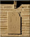
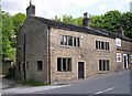
Date stone, 1762, Midgley Road, Mytholmroyd
Image: © Humphrey Bolton
Taken: 11 Dec 2012
0.04 miles
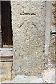
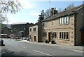
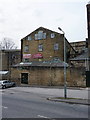
4
Former public house at Midgley Road / Sunny Bank junction
There is an OS benchmark Image on the right hand stone jamb of the door in the middle of the near section of the buildings
Image: © Luke Shaw
Taken: 21 Apr 2018
0.05 miles
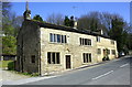
6
Old houses, Midgley Road, Mytholmroyd
The stone has been cleaned and is pale yellow like Cotswold limestone, although it is of course sandstone. The house on the right has the date 1762.
Image: © Humphrey Bolton
Taken: 22 Apr 2010
0.06 miles
7
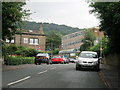
Midgley Road, Mytholmroyd
Calder High School in the distance on the right.
Image: © John H Darch
Taken: 15 Jul 2017
0.06 miles
8
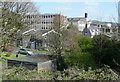
Calder High School, Mytholmroyd
On the site of White Lee Mill, which was shown as 'disused' on the 1907 OS map, although it was not yet shown as a school on the 1964 map. It is a 'Specialist Technology College and Training School'.
Image: © Humphrey Bolton
Taken: 22 Apr 2010
0.07 miles
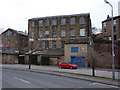
10
Walkey Clogs, Mount Pleasant Mills, Mytholmroyd
http://www.clogs.co.uk/
Image: © Alexander P Kapp
Taken: 3 Mar 2010
0.08 miles