IMAGES TAKEN NEAR TO
Oxford Terrace, HEBDEN BRIDGE, HX7 5JQ
Introduction
This page details the photographs taken nearby to Oxford Terrace, HX7 5JQ by members of the Geograph project.
The Geograph project started in 2005 with the aim of publishing, organising and preserving representative images for every square kilometre of Great Britain, Ireland and the Isle of Man.

There are currently over 7.5m images from over14,400 individuals and you can help contribute to the project by visiting https://www.geograph.org.uk
Image Map
Images are licensed for reuse under creativecommons.org/licenses/by-sa/2.0
Notes
- Clicking on the map will re-center to the selected point.
- The higher the marker number, the further away the image location is from the centre of the postcode.
Image Listing (260 Images Found)
Images are licensed for reuse under creativecommons.org/licenses/by-sa/2.0
Image
Details
Distance
1
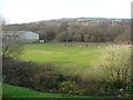
Recreation ground, Scout Road, Mytholmroyd
A cricket ground on the map, but now in use for informal football.
Image: © Humphrey Bolton
Taken: 27 Feb 2009
0.05 miles
2
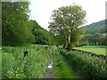
Hebden Royd Path 54, Mytholmroyd
Here the path is a cart track, passing a cricket ground.
Image: © Humphrey Bolton
Taken: 23 Jun 2011
0.05 miles
3
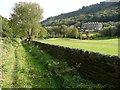
Hebden Royd Path 54 passing the recreation ground
The houses are on Scout Road.
Image: © Humphrey Bolton
Taken: 9 Oct 2012
0.05 miles
4
Sustrans Route 66, Mytholmroyd
Looking east from where the national cycle route leaves Mytholmroyd railway station.
Image: © michael ely
Taken: 28 Sep 2008
0.08 miles
5
Scout Road, Mytholmroyd, closed due to a landslip
I came here out of curiosity after reading a traffic incident report of a road closure causing moderate delay - a slight understatement! I found out later that this is a major landslip on a hillside below woodland containing a former asbestos tip. A school has been closed and fifteen houses evacuated. The closure does not even allow pedestrians to go through.
Image: © Humphrey Bolton
Taken: 14 Jan 2016
0.09 miles
6
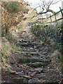
Stake Lane above Mytholmroyd
This is an ancient highway that climbs steeply up from the village, winding its way up the side of Hathershelf Scout
Image: © Phil Champion
Taken: 29 Jan 2006
0.09 miles
7
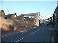
Square Shed, Scout Road, Mytholmroyd
Square is the name of the locality rather than the present shape of the factory, which is occupied by the Calder Weaving Co. Ltd., manufacturers of beds and blankets.
Image: © Humphrey Bolton
Taken: 29 Sep 2011
0.10 miles
8
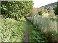
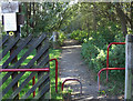
Hebden Royd Path 54
A well-used path between the railway embankment and an area of land with a tall fence.
Image: © Humphrey Bolton
Taken: 9 Oct 2012
0.10 miles
9
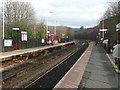
Mytholmroyd Station
Looking east. The station is up on an embankment, with access by steps on the left and a ramp on the right. If you find you are on the wrong platform, it is a long walk to reach the other one.
Image: © Humphrey Bolton
Taken: 27 Feb 2009
0.10 miles
10
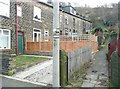
Cleveley Gardens, Mytholmroyd
Built when for a mill-worker to have a garden was unusual, I suppose. The fronts of the houses face a footpath rather than a road.
Image: © Humphrey Bolton
Taken: 27 Feb 2009
0.11 miles