IMAGES TAKEN NEAR TO
Cragg Road, HEBDEN BRIDGE, HX7 5EN
Introduction
This page details the photographs taken nearby to Cragg Road, HX7 5EN by members of the Geograph project.
The Geograph project started in 2005 with the aim of publishing, organising and preserving representative images for every square kilometre of Great Britain, Ireland and the Isle of Man.

There are currently over 7.5m images from over14,400 individuals and you can help contribute to the project by visiting https://www.geograph.org.uk
Image Map
Images are licensed for reuse under creativecommons.org/licenses/by-sa/2.0
Notes
- Clicking on the map will re-center to the selected point.
- The higher the marker number, the further away the image location is from the centre of the postcode.
Image Listing (222 Images Found)
Images are licensed for reuse under creativecommons.org/licenses/by-sa/2.0
Image
Details
Distance
1

Mytholmroyd Nurses' Home, Cragg Road
Mytholmroyd on the door lintel, Nurses on the lintel of the window on the left, and Home on that on the right.
Image: © Humphrey Bolton
Taken: 28 Oct 2011
0.01 miles
2

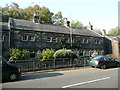
Buildings, Cragg Road B6138, Mytholmroyd
These are in a Victorian imitation of the 17C style, with drip mouldings over the windows and doors. The building on the right looks rather institutional, and on closer inspection the sign reads 'The Old Fire Station Pottery'.
Image: © Humphrey Bolton
Taken: 16 Oct 2008
0.01 miles
3
The former council offices, Cragg Road, Mytholmroyd
These were built subsequent to the formation of Mytholmroyd UDC (Urban District Council). It might have become redundant when Mytholmroyd joined Hebden Bridge to form Hebden Royd UDC. It appears to have been converted to houses.
Image: © Humphrey Bolton
Taken: 29 Sep 2011
0.01 miles
4
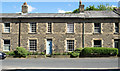
Mytholmroyd Nurses Home
Mytholmroyd Nurses Home is the house between the two drainpipes; the words used for the image title are cut into the stone lintels above the door and the two ground floor windows. Presumably it was a retirement home for nurses; now, surely, it's just an ordinarily occupied house. The road passing is the B6138, Cragg Road.
Image: © Trevor Littlewood
Taken: 3 Jun 2015
0.01 miles
5
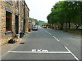
8km to the top, Cragg Road
Areas of road have also been outlined for repair, ready for the Tour de France in 2014.
Image: © Humphrey Bolton
Taken: 22 Jul 2013
0.03 miles
6

Terrace houses, Cragg Road, Mytholmroyd
These houses were built in the late 1930s, as they are shown in outline on the wartime six-inch map. They have the two-storey bay windows that were popular at that time.
Image: © Humphrey Bolton
Taken: 28 Oct 2011
0.04 miles
7

The Brook, Mytholmroyd
An estate of large detached houses on the site of Scarbottom Mill.
Image: © Humphrey Bolton
Taken: 28 Oct 2011
0.04 miles
8
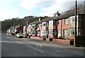
Terrace houses, Cragg Road, Mytholmroyd
In the style of the semi-detached houses with bay windows that are often seen. These were built in the late 1930s, as they are shown in outline on the wartime six-inch map.
Image: © Humphrey Bolton
Taken: 2 Feb 2012
0.04 miles
9

Footpath between Cragg Road and Stocks Lane
The steps are at the bottom of a flight of about 30. This path somehow missed being put on the rights-of-way map.
Image: © Humphrey Bolton
Taken: 28 Oct 2011
0.04 miles
10
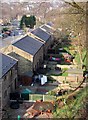
The Brook, Mytholmroyd
The back gardens of modern semi-detached houses on a cul-de-sac crossing Cragg Brook from Cragg Road, Mytholmroyd.
Image: © Paul Glazzard
Taken: 2 Apr 2007
0.05 miles