IMAGES TAKEN NEAR TO
Paddy Bridge Road, HEBDEN BRIDGE, HX7 5BP
Introduction
This page details the photographs taken nearby to Paddy Bridge Road, HX7 5BP by members of the Geograph project.
The Geograph project started in 2005 with the aim of publishing, organising and preserving representative images for every square kilometre of Great Britain, Ireland and the Isle of Man.

There are currently over 7.5m images from over14,400 individuals and you can help contribute to the project by visiting https://www.geograph.org.uk
Image Map
Images are licensed for reuse under creativecommons.org/licenses/by-sa/2.0
Notes
- Clicking on the map will re-center to the selected point.
- The higher the marker number, the further away the image location is from the centre of the postcode.
Image Listing (154 Images Found)
Images are licensed for reuse under creativecommons.org/licenses/by-sa/2.0
Image
Details
Distance
2
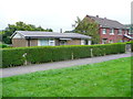
Caldene Avenue, Mytholmroyd
A long, straight suburban road parallel with the main road and now part of Sustrans Route 66.
Image: © Humphrey Bolton
Taken: 23 Jul 2011
0.03 miles
3
Paddy Bridge Road
This is part of Hebden Royd FP44.
Image: © Humphrey Bolton
Taken: 18 Aug 2014
0.03 miles
4
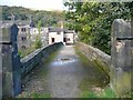
Paddy Bridge, Mytholmroyd
This is bridge number MVN2 135, wide enough for a road but only carrying Hebden Royd Footpath 44.
Image: © Humphrey Bolton
Taken: 28 Jul 2011
0.04 miles
5
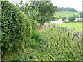
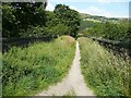
Overgrown footpath past the playing field
This is part of Hebden Royd FP44. The trouble is that people walk up the edge of the playing field, so the footpath does not get the footfall that is needs. This first section is not quite so bad now, after I got busy with my pocket secateurs.
Image: © Humphrey Bolton
Taken: 2 Sep 2013
0.07 miles
6
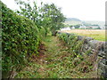
Hebden Royd FP44 alongside playing field
This path had become overgrown (Image]) but has now been cleared.
Image: © Humphrey Bolton
Taken: 18 Aug 2014
0.07 miles
8
Footbridge off Burnley Road A646, Mytholmroyd
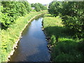
This seems to have been built to give access to a house on the south side of the river, and is now superseded as far as vehicles are concerned as a long residential road (Caldene Avenue) connects the house to the centre of Mytholmroyd.
Image: © Humphrey Bolton
Taken: 16 Oct 2008
0.08 miles
9
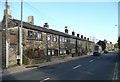
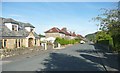
Terrace houses, Burnley Road A646, Mytholmroyd
These look like weavers' cottages, although the ones nearest the camera have had their windows altered and look quite different from the others whilst the overall width of the windows is the same. Beyond are later 19C houses.
Image: © Humphrey Bolton
Taken: 16 Oct 2008
0.08 miles
10
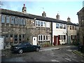
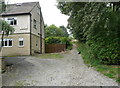
The Square, Mytholmroyd
Weavers' cottages set back from the main road and partly behind the row shown in Image
Image: © Humphrey Bolton
Taken: 16 Oct 2008
0.08 miles