IMAGES TAKEN NEAR TO
Heathfield Rise, SOWERBY BRIDGE, HX6 4RS
Introduction
This page details the photographs taken nearby to Heathfield Rise, HX6 4RS by members of the Geograph project.
The Geograph project started in 2005 with the aim of publishing, organising and preserving representative images for every square kilometre of Great Britain, Ireland and the Isle of Man.

There are currently over 7.5m images from over14,400 individuals and you can help contribute to the project by visiting https://www.geograph.org.uk
Image Map
Images are licensed for reuse under creativecommons.org/licenses/by-sa/2.0
Notes
- Clicking on the map will re-center to the selected point.
- The higher the marker number, the further away the image location is from the centre of the postcode.
Image Listing (50 Images Found)
Images are licensed for reuse under creativecommons.org/licenses/by-sa/2.0
Image
Details
Distance
1
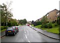
Heathfield Rise - Godly Lane, Rishworth
Image: © Betty Longbottom
Taken: 30 Sep 2008
0.07 miles
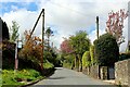
3
St John's C of E Primary School - Godly Lane, Rishworth
Image: © Betty Longbottom
Taken: 30 Sep 2008
0.10 miles
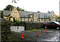
5
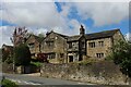
Upper Goat House, Rishworth
Splendid old Tudor house, dating back to the 16th Century located on Rishworth New Road. It has been split into 2 or 3 dwellings.
Grade II Listed Building
Image: © Chris Heaton
Taken: 7 May 2023
0.12 miles
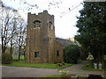
7
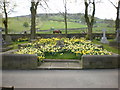
St John's Church, Rishworth, The Wheelwright family grave
Image: © Alexander P Kapp
Taken: 22 Apr 2009
0.14 miles
8
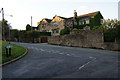
An older house in Rishworth
Rishworth has only a handful of older houses, and all the rest is new housing estates.
Image: © Bill Boaden
Taken: 7 Oct 2010
0.15 miles
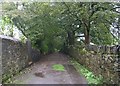
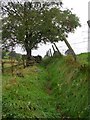
10
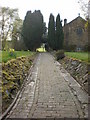
St John's Church, Rishworth, Path
Image: © Alexander P Kapp
Taken: 22 Apr 2009
0.16 miles