IMAGES TAKEN NEAR TO
St. Johns Close, SOWERBY BRIDGE, HX6 4RL
Introduction
This page details the photographs taken nearby to St. Johns Close, HX6 4RL by members of the Geograph project.
The Geograph project started in 2005 with the aim of publishing, organising and preserving representative images for every square kilometre of Great Britain, Ireland and the Isle of Man.

There are currently over 7.5m images from over14,400 individuals and you can help contribute to the project by visiting https://www.geograph.org.uk
Image Map
Images are licensed for reuse under creativecommons.org/licenses/by-sa/2.0
Notes
- Clicking on the map will re-center to the selected point.
- The higher the marker number, the further away the image location is from the centre of the postcode.
Image Listing (51 Images Found)
Images are licensed for reuse under creativecommons.org/licenses/by-sa/2.0
Image
Details
Distance
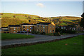
2
Playground - Rishworth New Road, Rishworth
Image: © Betty Longbottom
Taken: 30 Sep 2008
0.06 miles
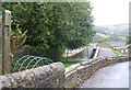
3
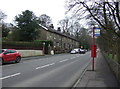
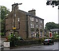
Oldham Road (A672), Rishworth
Heading north towards Ripponden.
Image: © JThomas
Taken: 14 Mar 2015
0.06 miles
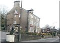
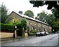
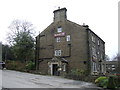
5
The Malt House - Oldham Road, Rishworth
Image: © Betty Longbottom
Taken: 30 Sep 2008
0.07 miles

8
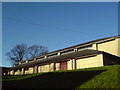
The Swimming Pool, Rishworth School, Oldham Road, Rishworth
Image: © alastair wallace
Taken: 17 Dec 2006
0.08 miles