IMAGES TAKEN NEAR TO
Rishworth, SOWERBY BRIDGE, HX6 4QX
Introduction
This page details the photographs taken nearby to HX6 4QX by members of the Geograph project.
The Geograph project started in 2005 with the aim of publishing, organising and preserving representative images for every square kilometre of Great Britain, Ireland and the Isle of Man.

There are currently over 7.5m images from over14,400 individuals and you can help contribute to the project by visiting https://www.geograph.org.uk
Image Map
Images are licensed for reuse under creativecommons.org/licenses/by-sa/2.0
Notes
- Clicking on the map will re-center to the selected point.
- The higher the marker number, the further away the image location is from the centre of the postcode.
Image Listing (33 Images Found)
Images are licensed for reuse under creativecommons.org/licenses/by-sa/2.0
Image
Details
Distance
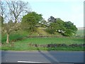
1
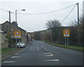
Booth Wood hamlet, Rishworth
The houses are mostly along the A672 Oldham Road, but a lane comes down to Spring Mill, which is out of sight in the valley bottom.
Image: © Humphrey Bolton
Taken: 12 May 2008
0.02 miles
2
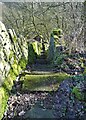
Steps down to the mills at Booth Wood
There were at one time four mills in the valley below making creative use of the Booth Dean stream. Here the steps descend to the sites of Spring Mill and Booth Wood Paper Mill. Both are now part of local history. No doubt mill workers used these steps day after day to get to and from work. It must have been a weary ascent at the end of a working day.
Image: © Neil Theasby
Taken: 6 Feb 2023
0.04 miles
3
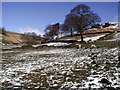
Black Hill, Booth Wood
Looking north-northeast from the track between Oldham Road and Booth Wood Mill.
Image: © Paul Glazzard
Taken: 19 Mar 2007
0.04 miles
4
Hill at Booth Wood, Rishworth
This hill, which does not seem to have a name, just reaches the 250m contour and is like an island between Booth Dean Clough and the side valley that is the route of the Oldham Road.
Image: © Humphrey Bolton
Taken: 12 May 2008
0.06 miles
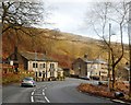
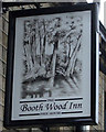
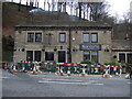
7
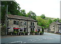
The Booth Wood Inn
This was previously the Old Bore. It is a pub-restaurant, and you can search for the menu on the web. It is a real ale pub, the 'Brewery tap' for the local Oates Brewery.
Image: © Humphrey Bolton
Taken: 19 May 2014
0.09 miles
9
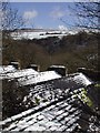
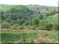
Booth Dean
Looking east-northeast across the roof of Booth Wood Mill towards Moselden Pasture and Royd Height beyond.
Image: © Paul Glazzard
Taken: 19 Mar 2007
0.10 miles