IMAGES TAKEN NEAR TO
Rishworth, SOWERBY BRIDGE, HX6 4PY
Introduction
This page details the photographs taken nearby to HX6 4PY by members of the Geograph project.
The Geograph project started in 2005 with the aim of publishing, organising and preserving representative images for every square kilometre of Great Britain, Ireland and the Isle of Man.

There are currently over 7.5m images from over14,400 individuals and you can help contribute to the project by visiting https://www.geograph.org.uk
Image Map
Images are licensed for reuse under creativecommons.org/licenses/by-sa/2.0
Notes
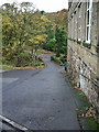
- Clicking on the map will re-center to the selected point.
- The higher the marker number, the further away the image location is from the centre of the postcode.
Image Listing (35 Images Found)
Images are licensed for reuse under creativecommons.org/licenses/by-sa/2.0
Image
Details
Distance
2
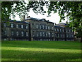
Rishworth School
A boarding and day school, founded 1724
Image: © Malcolm Street
Taken: 11 Sep 2005
0.12 miles
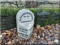
3
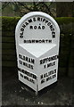
Milestone opposite Rishworth School
This is one of the standard West Riding stones of the late 19C, with a cast-iron face made in Liversedge.
Image: © Humphrey Bolton
Taken: 8 Apr 2014
0.13 miles
4
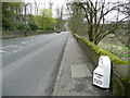
Location of milestone opposite Rishworth School
This milestone is on the A672. For a close view see Image
Image: © Humphrey Bolton
Taken: 8 Apr 2014
0.13 miles
5
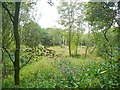
The former Rishworth railway station, Barkisland
This was the terminus of the line from Sowerby Bridge up the Ryburn Valley. It was intended to continue to Lancashire, but this never happened. The OS map shows what might be the remains of platforms, but nothing can now be seen of them but piles of rubble amongst the vegetation.
Image: © Humphrey Bolton
Taken: 17 Sep 2009
0.13 miles
6
Old milestone
On Oldham Road south of Ripponden and opposite Rishworth School is the slightly sunken West Riding CC milestone dating from 1893/94. Although not painted, the name of the foundry, Brayshaw & Booth of Liversedge is on the bevel. The backing stone has been painted white but when set up it was left bare. According to the contract awarded to the family firm of Gill & Frank Stead of Mirfield the metal attachment was to be painted blue with white letters. It is not known when the specification changed to black letters on white. There is a hole in the top of the stone. It is Grade II listed 407306.
Image: © Robert Glover
Taken: 14 Nov 2020
0.14 miles
7
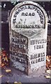
Old Milestone by the A672, Oldham Road, Rishworth
Metal plate attached to stone post by the A672, in parish of RIPPONDEN (CALDERDALE District), Oldham Road; opposite Rishworth School, by the road, on East side of road. Brayshaw & Booth iron casting, erected by the County Council in the 19th century.
Inscription reads:-
: OLDHAM / 12 MILES / MANCHESTER / 19 MILES : : OLDHAM & RIPPONDEN / ROAD / RISHWORTH : : RIPPONDEN / 1 MILE / HALIFAX / 6½ MILES :
Maker:-
: BRAYSHAW & BOOTH / MAKERS / LIVERSEDGE :
Grade II listed.
List Entry Number: 1232342 https://historicengland.org.uk/listing/the-list/list-entry/1232342
Milestone Society National ID: YW_RNOD01.
Image: © C Minto
Taken: 6 Mar 2004
0.14 miles
8
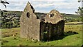
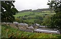
Building Remains on Folly Lane
Old maps mark perhaps a farmhouse on the opposite side of the old lane, of which very little can be seen above ground. This building with its two large round apertures is unusual. Is this the folly?
Image: © Kevin Waterhouse
Taken: 5 Sep 2022
0.14 miles
9
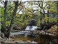
River Ryburn
With Slitheroe Bridge hidden in the trees, this bridge carries the A672 over the river.
Image: © Alexander P Kapp
Taken: 10 Nov 2008
0.14 miles
10
Rishworth School - viewed from Shaw Lane
Image: © Betty Longbottom
Taken: 30 Sep 2008
0.15 miles