IMAGES TAKEN NEAR TO
/Ash Hall Lane, SOWERBY BRIDGE, HX6 4NU
Introduction
This page details the photographs taken nearby to /Ash Hall Lane, HX6 4NU by members of the Geograph project.
The Geograph project started in 2005 with the aim of publishing, organising and preserving representative images for every square kilometre of Great Britain, Ireland and the Isle of Man.

There are currently over 7.5m images from over14,400 individuals and you can help contribute to the project by visiting https://www.geograph.org.uk
Image Map
Images are licensed for reuse under creativecommons.org/licenses/by-sa/2.0
Notes
- Clicking on the map will re-center to the selected point.
- The higher the marker number, the further away the image location is from the centre of the postcode.
Image Listing (35 Images Found)
Images are licensed for reuse under creativecommons.org/licenses/by-sa/2.0
Image
Details
Distance
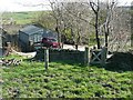
3
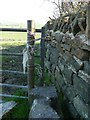
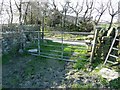
Is this a stile?
Whilst I got through without undue difficulty, I don't think this gap is wide enough to be classed as a stile, especially as the hinge bracket of the gate projects into the gap. See Image for context.
Image: © Humphrey Bolton
Taken: 6 May 2013
0.06 miles
4
Ripponden Footpath 12 at Ash Hall Lane
Ash Hall was in the field near the area seen between the two wooden posts. It has disappeared without trace. The footpath is invisible as you cross the field; you have to avoid veering to the right, and you will soon see a small stile into a Christmas tree plantation, see Image
Image: © Humphrey Bolton
Taken: 6 May 2013
0.06 miles
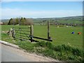
5
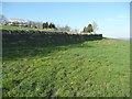
Gate on Ripponden Footpath 11 at Ash Hall Lane
This gate is tied at both ends with twine and cannot be opened. You could climb over, or use the narrow gap on the left as a stile. On the other side of the gate the 1850 map shows a building, probably a farm, captioned 'Cuckold Haven'. This was probably the end of Ash Hall Lane, although a narrow walled lane did continue past Waggon Farm.
Image: © Humphrey Bolton
Taken: 6 May 2013
0.07 miles
6
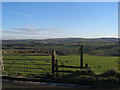
Ripponden Footpath 11 north-eastwards from Great Greave
This path converges on the bend in the wall and follows it around to Ash Hall Lane. The map shows another branch of the path going through the wall and up to Wagon Farm, but this is no longer usable and is unnecessary.
Image: © Humphrey Bolton
Taken: 6 May 2013
0.09 miles
8
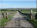
Gate on Ripponden Bridleway 8
This track leads from Greave Road to Flints Hall and the disused Flints Reservoir. It is part of the Calderdale Way.
Image: © Humphrey Bolton
Taken: 6 May 2013
0.11 miles
10
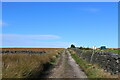
Calderdale Way heading towards Flints and Slate Delfs Hill
Image: © Chris Heaton
Taken: 6 Oct 2021
0.13 miles