IMAGES TAKEN NEAR TO
Ripponden, SOWERBY BRIDGE, HX6 4LS
Introduction
This page details the photographs taken nearby to HX6 4LS by members of the Geograph project.
The Geograph project started in 2005 with the aim of publishing, organising and preserving representative images for every square kilometre of Great Britain, Ireland and the Isle of Man.

There are currently over 7.5m images from over14,400 individuals and you can help contribute to the project by visiting https://www.geograph.org.uk
Image Map
Images are licensed for reuse under creativecommons.org/licenses/by-sa/2.0
Notes
- Clicking on the map will re-center to the selected point.
- The higher the marker number, the further away the image location is from the centre of the postcode.
Image Listing (22 Images Found)
Images are licensed for reuse under creativecommons.org/licenses/by-sa/2.0
Image
Details
Distance
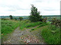
1
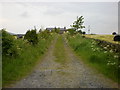
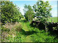
Track
Connects Ripponden Old Road and London Spring Road at Top o' th' Hill
Image: © Alexander P Kapp
Taken: 10 Jun 2009
0.03 miles
2
Wren Nest Road, Ripponden
Ripponden Bridleway 22/1.
Image: © Humphrey Bolton
Taken: 19 May 2022
0.08 miles
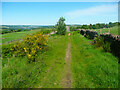
3
Wren Nest Road passing Wren Nest Farm, Ripponden
The bridleway divides here. The branch to the left goes along the access lane to the farm, whilst the one to the right is a pleasant grassy path.
Image: © Humphrey Bolton
Taken: 19 May 2022
0.13 miles
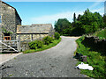
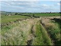
5
Ripponden Bridleway 10/10
This is a very pleasant short path between Wren Nest Farm and Green Lane.
Image: © Humphrey Bolton
Taken: 19 May 2022
0.15 miles
6
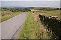
Blue Ball Road
Looking NE along Blue Ball Road at SE 021 196.
Image: © Mark Anderson
Taken: 15 Aug 2005
0.16 miles
7
Wren Nest Road, Soyland
The title 'Road' was probably given in an enclosure award. But the cirve suggests that there was already a track here. Perhaps a farmer or surveyor happened to come across a wren's nest when thinking about a suitable name!
Image: © Humphrey Bolton
Taken: 23 Sep 2008
0.16 miles
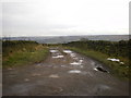
8
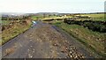
Blue Ball Road
Covered in debris probably washed out of the bridleway track that is Flight House Road which joins Blue Ball Road behind the camera. Another bridleway Wren Nest Road leads off to the right near the centre of this view
Image: © Kevin Waterhouse
Taken: 22 Feb 2022
0.16 miles
9
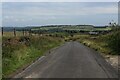
Blue Ball Road
Country lane heading north east.
Crow Hill can be seen in the distance.
Image: © Chris Heaton
Taken: 9 Jul 2023
0.18 miles
10
Dark Lane, Soyland
The gateway leads to some stables, and is as far as motor vehicles can go on this bridleway.
Image: © Humphrey Bolton
Taken: 20 Jun 2016
0.19 miles