IMAGES TAKEN NEAR TO
Dyson Lane, SOWERBY BRIDGE, HX6 4JX
Introduction
This page details the photographs taken nearby to Dyson Lane, HX6 4JX by members of the Geograph project.
The Geograph project started in 2005 with the aim of publishing, organising and preserving representative images for every square kilometre of Great Britain, Ireland and the Isle of Man.

There are currently over 7.5m images from over14,400 individuals and you can help contribute to the project by visiting https://www.geograph.org.uk
Image Map
Images are licensed for reuse under creativecommons.org/licenses/by-sa/2.0
Notes
- Clicking on the map will re-center to the selected point.
- The higher the marker number, the further away the image location is from the centre of the postcode.
Image Listing (82 Images Found)
Images are licensed for reuse under creativecommons.org/licenses/by-sa/2.0
Image
Details
Distance
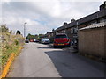
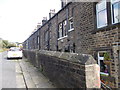
2
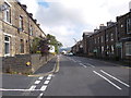
Rochdale Road - viewed from Castle Lane
Image: © Betty Longbottom
Taken: 19 Sep 2015
0.02 miles
3
Rochdale Road - viewed from Castle Lane
Image: © Betty Longbottom
Taken: 19 Sep 2015
0.02 miles
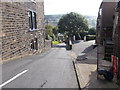
5
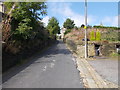
Dyson Lane - looking towards Rochdale Road
Image: © Betty Longbottom
Taken: 19 Sep 2015
0.04 miles
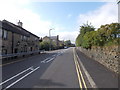
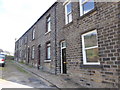
6
Butcher Arms, Rochdale Road, Ripponden
Image: © Alexander P Kapp
Taken: 11 Nov 2008
0.04 miles
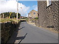
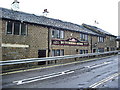
10
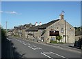
The Butchers Arms, Rochdale Road (A58), Ripponden
The top of Dyson Lane is just beyond the public house.
Image: © Humphrey Bolton
Taken: 10 Sep 2009
0.07 miles