IMAGES TAKEN NEAR TO
Mill Fold, SOWERBY BRIDGE, HX6 4DJ
Introduction
This page details the photographs taken nearby to Mill Fold, HX6 4DJ by members of the Geograph project.
The Geograph project started in 2005 with the aim of publishing, organising and preserving representative images for every square kilometre of Great Britain, Ireland and the Isle of Man.

There are currently over 7.5m images from over14,400 individuals and you can help contribute to the project by visiting https://www.geograph.org.uk
Image Map
Images are licensed for reuse under creativecommons.org/licenses/by-sa/2.0
Notes
- Clicking on the map will re-center to the selected point.
- The higher the marker number, the further away the image location is from the centre of the postcode.
Image Listing (180 Images Found)
Images are licensed for reuse under creativecommons.org/licenses/by-sa/2.0
Image
Details
Distance
1
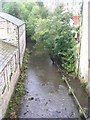
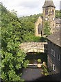
River Ryburn - Elland Road, Ripponden
Image: © Betty Longbottom
Taken: 30 Sep 2008
0.02 miles
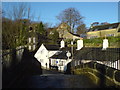
2
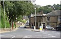
Elland Road, Ripponden, Soyland
The view from the junction with Halifax Road. The shop on the right has a taking-in door, so the first floor was presumably a warehouse. In the middle distance the parapets of the new bridge (part of the turnpike road) can be seen, and in the distance the former school.
Image: © Humphrey Bolton
Taken: 20 Aug 2006
0.02 miles
3
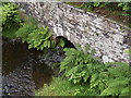
Cob Clough Culvert, Ripponden, Barkisland
This is where the Cob Clough stream enters the River Ryburn, seen from the packhorse bridge. In the 18C there was a disastrous flood which caused the culvert to burst and wash coffins and bodies out of the graveyard, some of which lodged in trees downstream - quite a grisly story!
Image: © Humphrey Bolton
Taken: 20 Aug 2006
0.02 miles
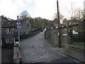
4
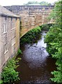
Elland Road Bridge, Ripponden.
This Grade II listed bridge over the River Ryburn was built in 1772 as part of a turnpike road. It was widened and altered in the mid-19C. It valso has two smaller land arches on the eastern side, giving access to cottages. The river is the boundary between Barkisland and Soyland townships. These became Urban Districts, and were merged as Ripponden UDC in 1937.
Image: © Humphrey Bolton
Taken: 20 Aug 2006
0.02 miles
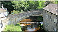
5
Ripponden Old Bridge
A packhorse bridge that existed in 1307 and has been rebuilt several times since. Although narrow, it is still open to motor traffic, with a 5t weight limit. Also what is probably a sewer pipe, bridging the River Ryburn at a low level.
Image: © Humphrey Bolton
Taken: 20 Aug 2006
0.02 miles
6
The Old Bridge Inn, Ripponden
The oldest pub in Yorkshire
Image: © alastair wallace
Taken: 17 Dec 2006
0.02 miles
7

Elland Road Bridge, Ripponden
A grade II listed turnpike bridge over the river Ryburn (list entry 1278207). Built in 1772, and therefore ironically older than the more highly listed 'old' bridge, which was rebuilt in 1973 Image
Image: © Stephen Craven
Taken: 5 Oct 2024
0.03 miles
9
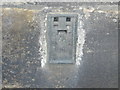
Ordnance Survey Flush Bracket 846
This bracket can be found on the wall of a house in Elland Road.
For more detail see : http://www.bench-marks.org.uk/bm9851
Image: © Peter Wood
Taken: 30 Jan 2013
0.04 miles
10
Ripponden Old Bridge
Viewed from the more modern Elland Road Bridge, both across the River Ryburn
Image: © Kevin Waterhouse
Taken: 24 Jun 2020
0.04 miles