IMAGES TAKEN NEAR TO
Mill Fold, SOWERBY BRIDGE, HX6 4DH
Introduction
This page details the photographs taken nearby to Mill Fold, HX6 4DH by members of the Geograph project.
The Geograph project started in 2005 with the aim of publishing, organising and preserving representative images for every square kilometre of Great Britain, Ireland and the Isle of Man.

There are currently over 7.5m images from over14,400 individuals and you can help contribute to the project by visiting https://www.geograph.org.uk
Image Map
Images are licensed for reuse under creativecommons.org/licenses/by-sa/2.0
Notes
- Clicking on the map will re-center to the selected point.
- The higher the marker number, the further away the image location is from the centre of the postcode.
Image Listing (179 Images Found)
Images are licensed for reuse under creativecommons.org/licenses/by-sa/2.0
Image
Details
Distance
1
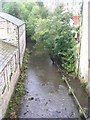
River Ryburn - Elland Road, Ripponden
Image: © Betty Longbottom
Taken: 30 Sep 2008
0.01 miles
2

Elland Road Bridge, Ripponden
A grade II listed turnpike bridge over the river Ryburn (list entry 1278207). Built in 1772, and therefore ironically older than the more highly listed 'old' bridge, which was rebuilt in 1973 Image
Image: © Stephen Craven
Taken: 5 Oct 2024
0.01 miles
3
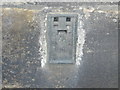
Ordnance Survey Flush Bracket 846
This bracket can be found on the wall of a house in Elland Road.
For more detail see : http://www.bench-marks.org.uk/bm9851
Image: © Peter Wood
Taken: 30 Jan 2013
0.02 miles
5
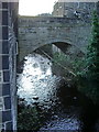
Ripponden Old Bridge
Viewed from the more modern Elland Road Bridge, both across the River Ryburn
Image: © Kevin Waterhouse
Taken: 24 Jun 2020
0.03 miles
6
Elland Road Bridge over the River Ryburn
Image: © Alexander P Kapp
Taken: 31 Oct 2008
0.03 miles
7
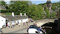
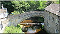
Old Bridge Inn & Old Bridge over R Ryburn at Ripponden
Image: © Colin Park
Taken: 7 May 2018
0.03 miles
9
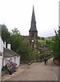
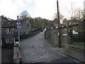
Priest Lane and the packhorse bridge, Ripponden, Soyland
Part of the ancient packhorse route to Rochdale. The bridge was first mentioned in a document of 1307. The Bridge Inn is on the left.
Image: © Humphrey Bolton
Taken: 20 Aug 2006
0.03 miles
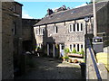
10
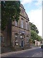
The Conservative Club, Halifax Road, Ripponden. Soyland
The date at the top is hard to read on the photo, but looks like 1900.
Image: © Humphrey Bolton
Taken: 20 Aug 2006
0.03 miles