IMAGES TAKEN NEAR TO
Waterside Close, SOWERBY BRIDGE, HX6 4BX
Introduction
This page details the photographs taken nearby to Waterside Close, HX6 4BX by members of the Geograph project.
The Geograph project started in 2005 with the aim of publishing, organising and preserving representative images for every square kilometre of Great Britain, Ireland and the Isle of Man.

There are currently over 7.5m images from over14,400 individuals and you can help contribute to the project by visiting https://www.geograph.org.uk
Image Map
Images are licensed for reuse under creativecommons.org/licenses/by-sa/2.0
Notes
- Clicking on the map will re-center to the selected point.
- The higher the marker number, the further away the image location is from the centre of the postcode.
Image Listing (168 Images Found)
Images are licensed for reuse under creativecommons.org/licenses/by-sa/2.0
Image
Details
Distance
2
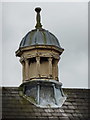
Central Hall, Oldham Road, Ripponden, Cupola
Image: © Alexander P Kapp
Taken: 13 Apr 2010
0.01 miles
3
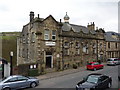
Central Hall, Oldham Road, Ripponden
Image: © Alexander P Kapp
Taken: 13 Apr 2010
0.03 miles
4
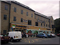
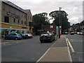
Co-operative food store and Central apartments, Ripponden
"Work. Life. Discover the perfect balance at Central. 24 stylish, individual apartments close to West Yorkshire's most important commuter links and at the heart of its most beautiful countryside. With its striking stone facade, Central offers apartments that bring a new dimension to modern living... on the ground floor, you'll discover a convenience store. So even when you have to work long into the night, you'll never be without the essentials you need" (quoting from the marketing bumf).
Or 24 flats above a supermarket on the A58. Built by B & D Croft.
Image: © Phil Champion
Taken: 29 Jul 2010
0.03 miles
5
Co-operative supermarket and Central apartments, Rochdale Road, Hebden Bridge
Image: © Phil Champion
Taken: 29 Jul 2010
0.03 miles
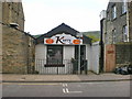
7
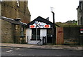
Kurry Hut
Beside the A672 at Ripponden.
Image: © David Rogers
Taken: 27 Feb 2009
0.04 miles
8
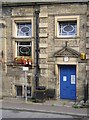
Detail of Central Hall, Oldham Road, Ripponden, Soyland
The doorway is still in a version of Classical style, but the stained glass in the windows is art-nouveau.
Image: © Humphrey Bolton
Taken: 20 Aug 2006
0.04 miles
9
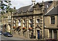
Central Hall, Oldham Road, Ripponden, Soyland
This was built as the Liberal Club and Central Hall in 1903.
Image: © Humphrey Bolton
Taken: 20 Aug 2006
0.04 miles
10
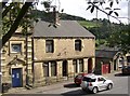
Old Post Office, Oldham Road, Ripponden, Soyland
The left-hand house of this pair has that name. It must have closed quite recently, as it is still a PO on my OS street map. Note also the small building on the right, perhaps built as a lock-up shop.
Image: © Humphrey Bolton
Taken: 20 Aug 2006
0.04 miles