IMAGES TAKEN NEAR TO
Norland, SOWERBY BRIDGE, HX6 3SA
Introduction
This page details the photographs taken nearby to HX6 3SA by members of the Geograph project.
The Geograph project started in 2005 with the aim of publishing, organising and preserving representative images for every square kilometre of Great Britain, Ireland and the Isle of Man.

There are currently over 7.5m images from over14,400 individuals and you can help contribute to the project by visiting https://www.geograph.org.uk
Image Map
Images are licensed for reuse under creativecommons.org/licenses/by-sa/2.0
Notes
- Clicking on the map will re-center to the selected point.
- The higher the marker number, the further away the image location is from the centre of the postcode.
Image Listing (49 Images Found)
Images are licensed for reuse under creativecommons.org/licenses/by-sa/2.0
Image
Details
Distance
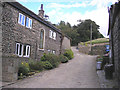
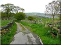
1
Longley Lane at Longley, Norland
The lane is shown with green dots on the Explorer map, and is a publicly maintained road.
Image: © Humphrey Bolton
Taken: 6 May 2012
0.01 miles
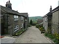
2
Longley
A well paved lane past Upper Longley Farm.
Image: © John Illingworth
Taken: 8 Aug 2007
0.02 miles
3
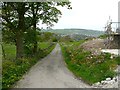
Longley Lane at Longley
Below the farm, there is a bend in the road and the surface changes from stone setts to tarmac. A new house is under construction on the right.
Image: © Humphrey Bolton
Taken: 6 May 2012
0.05 miles
4
Sowerby Bridge Footpath 136 approaching Longley, Norland
The local dogs take a close interest in passing ramblers.
Image: © Humphrey Bolton
Taken: 6 May 2012
0.06 miles
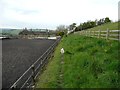
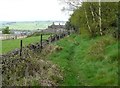
5
Longley Lane, Norland
Here the road surface changes from tarmac to stone setts. The lane is only suitable for motor vehicles as far as Dodge Royd. There is an old water trough on the right.
Image: © Humphrey Bolton
Taken: 6 May 2012
0.07 miles
6
98 Sowerby Bridge Footpath 136 in Longley Wood, Norland
Although this wood is mainly holly trees, there are some more open areas where birch trees have grown.
Image: © Humphrey Bolton
Taken: 6 May 2012
0.11 miles
8
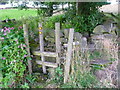
Stiles and waymarks, Norland
Here you can turn right of go straight on over a stone stile and battle through the undergrowth.
Image: © Humphrey Bolton
Taken: 23 Aug 2015
0.12 miles
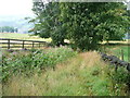
9
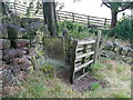
A gated stile, Norland
This is where the footpath in Image leaves the track and goes along the edge of a field to East Longley. The use of a pallet to make a gate to cover a stone squeeze stile seems to be a popular.
Image: © Humphrey Bolton
Taken: 23 Aug 2015
0.12 miles
10
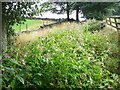
Footpath in an overgrown lane, Norland
The grass track has been colonised by Himalayan Balsam.
Image: © Humphrey Bolton
Taken: 23 Aug 2015
0.12 miles