IMAGES TAKEN NEAR TO
Westfield, SOWERBY BRIDGE, HX6 3RL
Introduction
This page details the photographs taken nearby to Westfield, HX6 3RL by members of the Geograph project.
The Geograph project started in 2005 with the aim of publishing, organising and preserving representative images for every square kilometre of Great Britain, Ireland and the Isle of Man.

There are currently over 7.5m images from over14,400 individuals and you can help contribute to the project by visiting https://www.geograph.org.uk
Image Map
Images are licensed for reuse under creativecommons.org/licenses/by-sa/2.0
Notes
- Clicking on the map will re-center to the selected point.
- The higher the marker number, the further away the image location is from the centre of the postcode.
Image Listing (63 Images Found)
Images are licensed for reuse under creativecommons.org/licenses/by-sa/2.0
Image
Details
Distance
1
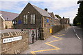
Norland Junior & Infant School
Looking NE along Berry Moor Road.
Image: © Mark Anderson
Taken: 9 Aug 2005
0.02 miles
2
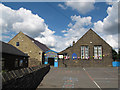
Norland village school
Norland is a very small village but still supports a school: I presume many of the pupils come from Sowerby Bridge at the bottom of the hill. See also Image
Image: © Stephen Craven
Taken: 6 Jul 2014
0.03 miles
4
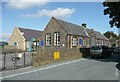
The school, Norland
One small change since the 1995 image Image: There is now a covered way between the old and new buildings.
Image: © Humphrey Bolton
Taken: 23 Sep 2008
0.04 miles
5
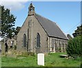
St Luke's Church, Norland
Built in 1866. Norland became a separate ecclesiastical parish in 1877. Immediately before that it was a chapelry of Sowerby Bridge parish, but originally it was in the ancient parish of Halifax.
Image: © Humphrey Bolton
Taken: 23 Sep 2008
0.04 miles
6
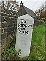
Old milestone
In Norland south east of Sowerby Bridge on Clough Road near the church. This stone is well looked after. The face to the wall is inscribed To/Sowerby/2+M. To/Ealand/2+M and To/Halifax/2+M are on the other two faces. Rather more than 2 miles each way to the four towns. + perhaps means add on your own distance!
Image: © Robert Glover
Taken: 11 Nov 2020
0.04 miles
7
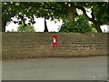
Postbox in the wall of St Luke's churchyard
A George VI box.
Image: © Stephen Craven
Taken: 18 Aug 2022
0.04 miles
9
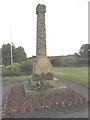
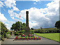
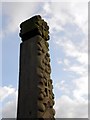
Norland War Memorial
The design of the Memorial is unique. It was the work of the Incumbent of St Luke's Church in the early 1920s. He incorporated designs from the end stones and other features of houses in the township into the carved stone pillar. The tablet containing the names of those commemorated is in the small garden behind the pillar.
The flag pole to the left of the memorial is within the restored village pinfold.
Image: © Michael Steele
Taken: 23 Jun 2010
0.05 miles
10
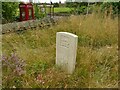
Commonwealth War Grave in St Luke's churchyard
This appeared to be the only one of its type on this site. Memorial to Pte C A Lumb, died 1942 aged 28. Born at the start of the First World War, failed to survive the second.
Image: © Stephen Craven
Taken: 18 Aug 2022
0.05 miles