IMAGES TAKEN NEAR TO
Birchfield, SOWERBY BRIDGE, HX6 3RH
Introduction
This page details the photographs taken nearby to Birchfield, HX6 3RH by members of the Geograph project.
The Geograph project started in 2005 with the aim of publishing, organising and preserving representative images for every square kilometre of Great Britain, Ireland and the Isle of Man.

There are currently over 7.5m images from over14,400 individuals and you can help contribute to the project by visiting https://www.geograph.org.uk
Image Map
Images are licensed for reuse under creativecommons.org/licenses/by-sa/2.0
Notes
- Clicking on the map will re-center to the selected point.
- The higher the marker number, the further away the image location is from the centre of the postcode.
Image Listing (103 Images Found)
Images are licensed for reuse under creativecommons.org/licenses/by-sa/2.0
Image
Details
Distance
1
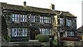
Fallingworth Hall
On Norland Town Road, Norland
Image: © Kevin Waterhouse
Taken: 22 Nov 2020
0.03 miles
2
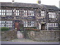
Fallingworth Hall
Fine old house in Norland, dated 1642. This is now divided into two houses.
Image: © John Illingworth
Taken: 1 Nov 2006
0.03 miles
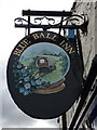
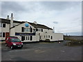
3
The former Blue Ball Inn
The name suggests that the inn might have been on a coaching route, perhaps from Burnley to Huddersfield.
Image: © Humphrey Bolton
Taken: 3 Jul 2014
0.08 miles
5
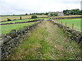
Sowerby Bridge Footpath 78 in a walled lane
No problems when its dry, but expect wet trousers if it is raining!
Image: © Humphrey Bolton
Taken: 3 Jul 2014
0.09 miles
7
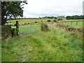
Junction of two branches of Sowerby Bridge Footpath 76
The grassy lane straight forward goes straight to the junction of Moor End Lane, London Road and New Clough Road. The path on the left goes to London Road via a patch of bracken that could do with more trampling!
Image: © Humphrey Bolton
Taken: 3 Jul 2014
0.10 miles
8
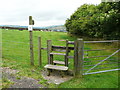
Stile on Sowerby Bridge Footpath 78
This is where the path leaves the car park of the former Blue Ball Inn.
Image: © Humphrey Bolton
Taken: 3 Jul 2014
0.11 miles
9
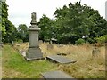
St Luke's churchyard, Norland
A 19th century burial ground, still in use.
Image: © Stephen Craven
Taken: 18 Aug 2022
0.11 miles
10
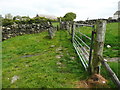
Stone setts across a gateway, on Sowerby Bridge FP78, Norland
Image: © Humphrey Bolton
Taken: 15 Jun 2015
0.11 miles