IMAGES TAKEN NEAR TO
Norland, SOWERBY BRIDGE, HX6 3QJ
Introduction
This page details the photographs taken nearby to HX6 3QJ by members of the Geograph project.
The Geograph project started in 2005 with the aim of publishing, organising and preserving representative images for every square kilometre of Great Britain, Ireland and the Isle of Man.

There are currently over 7.5m images from over14,400 individuals and you can help contribute to the project by visiting https://www.geograph.org.uk
Image Map
Images are licensed for reuse under creativecommons.org/licenses/by-sa/2.0
Notes
- Clicking on the map will re-center to the selected point.
- The higher the marker number, the further away the image location is from the centre of the postcode.
Image Listing (73 Images Found)
Images are licensed for reuse under creativecommons.org/licenses/by-sa/2.0
Image
Details
Distance
2
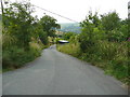
Dubious public footpath off Hob Lane, Norland
This path is shown on the OS map, and has a public footpath signpost at each end. However it is not shown on the council's on-line rights-of-way map.
Image: © Humphrey Bolton
Taken: 22 Aug 2015
0.03 miles
3
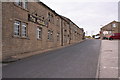
The Hobbit Public House and Hotel
Looking SW.
Image: © Mark Anderson
Taken: 9 Aug 2005
0.03 miles
4
Hob Lane, Norland, showing the position of the water main marker post
This is the post shown in Image
Image: © Humphrey Bolton
Taken: 23 Aug 2015
0.04 miles
5
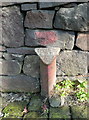
Water main marker post, Hob Lane
This is almost certainly one of the Morley Corporation Water Works posts, on the 15 inch main between Withens Clough Reservoir and Morley. The main comes through Sowerby and goes through Norland and Greetland.
Image: © Humphrey Bolton
Taken: 22 Aug 2015
0.05 miles
6
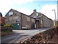
The Hobbit Inn
The Hobbit Inn provides an unsurpassed view over Sowerby Bridge. The road access gives great cause for concern to visitors, however the local population appear to have nerves of steel !
Image: © Len Williams
Taken: 27 Mar 2010
0.05 miles
7
Footpath sign at Prospect Terrace, Norland
I tried to use the path, but could not find a way through.
Image: © Humphrey Bolton
Taken: 23 Aug 2015
0.05 miles
8
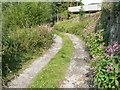
Dubious public footpath off Hob Lane, Norland
This path is shown on the OS map, and has a public footpath signpost at each end (at this end it is the slender metal post at the top centre of the image). However it is not shown on the council's on-line rights-of-way map.
Image: © Humphrey Bolton
Taken: 22 Aug 2015
0.05 miles
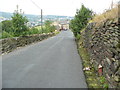
9
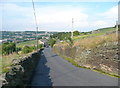
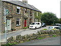
Hob Lane, Norland
This view is looking down the lane from the end of FP93. The Hobbit Inn is round the bend to the right, in the distance.
Image: © Humphrey Bolton
Taken: 22 Aug 2015
0.06 miles
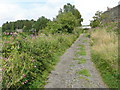
10
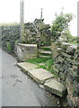
Steps on the footpath to East Longley at Hob Lane, Norland
Image: © Humphrey Bolton
Taken: 23 Aug 2015
0.06 miles